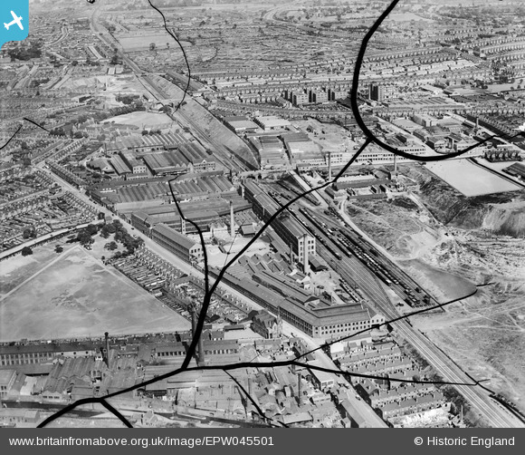
EPW045501 ENGLAND (1934). The Durex Abrasives Works and environs, Saltley, 1934. This image has been produced from a damaged negative.
© Copyright OpenStreetMap contributors and licensed by the OpenStreetMap Foundation. 2026. Cartography is licensed as CC BY-SA.
Nearby Images (48)
Details
| Title | [EPW045501] The Durex Abrasives Works and environs, Saltley, 1934. This image has been produced from a damaged negative. |
| Reference | EPW045501 |
| Date | July-1934 |
| Link | |
| Place name | SALTLEY |
| Parish | |
| District | |
| Country | ENGLAND |
| Easting / Northing | 409757, 287264 |
| Longitude / Latitude | -1.8563096147116, 52.482841730885 |
| National Grid Reference | SP098873 |
Pins
Be the first to add a comment to this image!


![[EPW045501] The Durex Abrasives Works and environs, Saltley, 1934. This image has been produced from a damaged negative.](http://britainfromabove.org.uk/sites/all/libraries/aerofilms-images/public/100x100/EPW/045/EPW045501.jpg)
![[EPW036137] The Wolseley Tool and Motor Car Works and Adderley Park Brick Works, Birmingham, 1931](http://britainfromabove.org.uk/sites/all/libraries/aerofilms-images/public/100x100/EPW/036/EPW036137.jpg)
![[EPW044604] The Morris Motor Car Works and the Durex Abrasives Works, Saltley, 1934](http://britainfromabove.org.uk/sites/all/libraries/aerofilms-images/public/100x100/EPW/044/EPW044604.jpg)
![[EPW036132] The Wolseley Tool and Motor Car Works, Birmingham, 1931](http://britainfromabove.org.uk/sites/all/libraries/aerofilms-images/public/100x100/EPW/036/EPW036132.jpg)
![[EPW005705] Wolseley Motor Works and Adderley Park Brick Works, Adderley Park Station, 1921](http://britainfromabove.org.uk/sites/all/libraries/aerofilms-images/public/100x100/EPW/005/EPW005705.jpg)
![[EPW036133] The Wolseley Tool and Motor Car Works, Birmingham, 1931](http://britainfromabove.org.uk/sites/all/libraries/aerofilms-images/public/100x100/EPW/036/EPW036133.jpg)
![[EPW037049] The Wolseley Motor Works and Adderley Park Brick Works, Saltley, 1931](http://britainfromabove.org.uk/sites/all/libraries/aerofilms-images/public/100x100/EPW/037/EPW037049.jpg)
![[EPW036924] The Wolseley Motor Works and environs, Birmingham, 1931](http://britainfromabove.org.uk/sites/all/libraries/aerofilms-images/public/100x100/EPW/036/EPW036924.jpg)
![[EPW037047] The Wolseley Motor Works and Adderley Park Brick Works, Saltley, 1931](http://britainfromabove.org.uk/sites/all/libraries/aerofilms-images/public/100x100/EPW/037/EPW037047.jpg)
![[EPW031294] The Adderley Park Motor Works and the Adderley Park Brick Works, Birmingham, 1930](http://britainfromabove.org.uk/sites/all/libraries/aerofilms-images/public/100x100/EPW/031/EPW031294.jpg)
![[EPW037051] The Wolseley Motor Works and Adderley Park Brick Works, Saltley, 1931](http://britainfromabove.org.uk/sites/all/libraries/aerofilms-images/public/100x100/EPW/037/EPW037051.jpg)
![[EPW044600] The Durex Abrasives Works, the Morris Motor Car Works and Adderley Park, Saltley, 1934](http://britainfromabove.org.uk/sites/all/libraries/aerofilms-images/public/100x100/EPW/044/EPW044600.jpg)
![[EPW037050] The Wolseley Motor Works and Adderley Park Brick Works, Saltley, 1931](http://britainfromabove.org.uk/sites/all/libraries/aerofilms-images/public/100x100/EPW/037/EPW037050.jpg)
![[EPW036130] The Wolseley Tool and Motor Car Works, Birmingham, 1931](http://britainfromabove.org.uk/sites/all/libraries/aerofilms-images/public/100x100/EPW/036/EPW036130.jpg)
![[EPW036921] The Wolseley Motor Works, Adderley Park Brick Works and environs, Birmingham, 1931](http://britainfromabove.org.uk/sites/all/libraries/aerofilms-images/public/100x100/EPW/036/EPW036921.jpg)
![[EPW031295] The Adderley Park Motor Works and the Adderley Park Brick Works, Birmingham, 1930](http://britainfromabove.org.uk/sites/all/libraries/aerofilms-images/public/100x100/EPW/031/EPW031295.jpg)
![[EPW036127] The Wolseley Tool and Motor Car Works, Birmingham, 1931](http://britainfromabove.org.uk/sites/all/libraries/aerofilms-images/public/100x100/EPW/036/EPW036127.jpg)
![[EPW036131] The Wolseley Tool and Motor Car Works, Birmingham, 1931](http://britainfromabove.org.uk/sites/all/libraries/aerofilms-images/public/100x100/EPW/036/EPW036131.jpg)
![[EPW036923] The Wolseley Motor Works and environs, Birmingham, 1931](http://britainfromabove.org.uk/sites/all/libraries/aerofilms-images/public/100x100/EPW/036/EPW036923.jpg)
![[EPW036925] The Wolseley Motor Works and environs, Birmingham, 1931](http://britainfromabove.org.uk/sites/all/libraries/aerofilms-images/public/100x100/EPW/036/EPW036925.jpg)
![[EPW036134] The Wolseley Tool and Motor Car Works, Birmingham, 1931](http://britainfromabove.org.uk/sites/all/libraries/aerofilms-images/public/100x100/EPW/036/EPW036134.jpg)
![[EPW036129] The Wolseley Tool and Motor Car Works, Birmingham, 1931](http://britainfromabove.org.uk/sites/all/libraries/aerofilms-images/public/100x100/EPW/036/EPW036129.jpg)
![[EPW045022] The Morris Motor Works, Adderley Park and the surrounding residential area, Saltley, 1934](http://britainfromabove.org.uk/sites/all/libraries/aerofilms-images/public/100x100/EPW/045/EPW045022.jpg)
![[EPW037041] The Wolseley Motor Works and Adderley Park Brick Works, Saltley, 1931](http://britainfromabove.org.uk/sites/all/libraries/aerofilms-images/public/100x100/EPW/037/EPW037041.jpg)
![[EPW044601] The Durex Abrasives Works and the Morris Motor Car Works, Saltley, 1934](http://britainfromabove.org.uk/sites/all/libraries/aerofilms-images/public/100x100/EPW/044/EPW044601.jpg)
![[EPW037046] The Wolseley Motor Works and Adderley Park Brick Works, Saltley, 1931](http://britainfromabove.org.uk/sites/all/libraries/aerofilms-images/public/100x100/EPW/037/EPW037046.jpg)
![[EPW044606] The Morris Motor Car Works, the Durex Abrasives Works and Adderley Park, Saltley, 1934](http://britainfromabove.org.uk/sites/all/libraries/aerofilms-images/public/100x100/EPW/044/EPW044606.jpg)
![[EPW044597] The Durex Abrasives Works and the Morris Motor Car Works, Saltley, 1934](http://britainfromabove.org.uk/sites/all/libraries/aerofilms-images/public/100x100/EPW/044/EPW044597.jpg)
![[EPW044605] The Morris Motor Car Works, the Durex Abrasives Works and Adderley Park, Saltley, 1934](http://britainfromabove.org.uk/sites/all/libraries/aerofilms-images/public/100x100/EPW/044/EPW044605.jpg)
![[EPW036919] The Wolseley Motor Works and environs, Birmingham, 1931](http://britainfromabove.org.uk/sites/all/libraries/aerofilms-images/public/100x100/EPW/036/EPW036919.jpg)
![[EPW045020] The Morris Motor Works, Adderley Park and the surrounding residential area, Saltley, 1934](http://britainfromabove.org.uk/sites/all/libraries/aerofilms-images/public/100x100/EPW/045/EPW045020.jpg)
![[EPW045019] The Morris Motor Works, Adderley Park and the surrounding residential area, Saltley, 1934](http://britainfromabove.org.uk/sites/all/libraries/aerofilms-images/public/100x100/EPW/045/EPW045019.jpg)
![[EPW044603] The Morris Motor Car Works, Adderley Park and St Saviour's Church, Saltley, 1934](http://britainfromabove.org.uk/sites/all/libraries/aerofilms-images/public/100x100/EPW/044/EPW044603.jpg)
![[EPW044602] The Durex Abrasives Works, the Morris Motor Car Works and Adderley Park, Saltley, 1934](http://britainfromabove.org.uk/sites/all/libraries/aerofilms-images/public/100x100/EPW/044/EPW044602.jpg)
![[EPW037045] The Wolseley Motor Works and Adderley Park Brick Works, Saltley, 1931](http://britainfromabove.org.uk/sites/all/libraries/aerofilms-images/public/100x100/EPW/037/EPW037045.jpg)
![[EPW037044] The Wolseley Motor Works and Adderley Park Brick Works, Saltley, 1931](http://britainfromabove.org.uk/sites/all/libraries/aerofilms-images/public/100x100/EPW/037/EPW037044.jpg)
![[EPW037043] The Wolseley Motor Works and Adderley Park Brick Works, Saltley, 1931](http://britainfromabove.org.uk/sites/all/libraries/aerofilms-images/public/100x100/EPW/037/EPW037043.jpg)
![[EPW045025] The Durex Abrasives Works, Adderley Park and the Morris Motor Works, Saltley, 1934](http://britainfromabove.org.uk/sites/all/libraries/aerofilms-images/public/100x100/EPW/045/EPW045025.jpg)
![[EPW045023] The Morris Motor Works, Adderley Park and the surrounding residential area, Saltley, 1934](http://britainfromabove.org.uk/sites/all/libraries/aerofilms-images/public/100x100/EPW/045/EPW045023.jpg)
![[EPW045027] The Durex Abrasives Works, Adderley Park and surrounding residential area, Saltley, 1934](http://britainfromabove.org.uk/sites/all/libraries/aerofilms-images/public/100x100/EPW/045/EPW045027.jpg)
![[EPW045021] The Morris Motor Works, Adderley Park and the surrounding residential area, Saltley, 1934](http://britainfromabove.org.uk/sites/all/libraries/aerofilms-images/public/100x100/EPW/045/EPW045021.jpg)
![[EPW045028] The Durex Abrasives Works, the Morris Motor Works and surrounding residential area, Saltley, 1934](http://britainfromabove.org.uk/sites/all/libraries/aerofilms-images/public/100x100/EPW/045/EPW045028.jpg)
![[EPW045498] The Durex Abrasives Works and adjacent Motor Works on Arden Road, Saltley, 1934. This image has been produced from a damaged negative.](http://britainfromabove.org.uk/sites/all/libraries/aerofilms-images/public/100x100/EPW/045/EPW045498.jpg)
![[EPW045026] The Durex Abrasives Works and Adderley Park, Saltley, 1934](http://britainfromabove.org.uk/sites/all/libraries/aerofilms-images/public/100x100/EPW/045/EPW045026.jpg)
![[EPW044598] The Durex Abrasives Works, the Morris Motor Car Works and Adderley Park, Saltley, 1934](http://britainfromabove.org.uk/sites/all/libraries/aerofilms-images/public/100x100/EPW/044/EPW044598.jpg)
![[EPW045500] The Durex Abrasives Works and adjacent Motor Works on Arden Road, Saltley, 1934. This image has been produced from a damaged negative.](http://britainfromabove.org.uk/sites/all/libraries/aerofilms-images/public/100x100/EPW/045/EPW045500.jpg)
![[EPW045499] The Durex Abrasives Works and adjacent Motor Works on Arden Road, Saltley, 1934. This image has been produced from a damaged negative.](http://britainfromabove.org.uk/sites/all/libraries/aerofilms-images/public/100x100/EPW/045/EPW045499.jpg)
![[EPW044607] The Morris Motor Car Works, Adderley Park and St Saviour's Church, Saltley, 1934](http://britainfromabove.org.uk/sites/all/libraries/aerofilms-images/public/100x100/EPW/044/EPW044607.jpg)