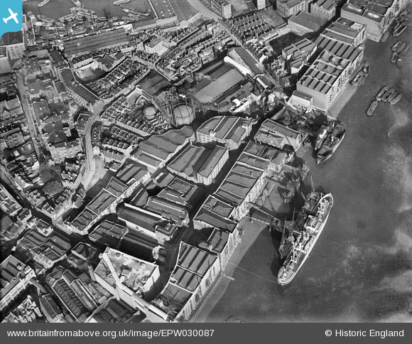
EPW030087 ENGLAND (1929). The Middleton and St Bride's Wharf, Prusom Street and environs, Wapping, 1929
© Copyright OpenStreetMap contributors and licensed by the OpenStreetMap Foundation. 2026. Cartography is licensed as CC BY-SA.
Nearby Images (22)
Details
| Title | [EPW030087] The Middleton and St Bride's Wharf, Prusom Street and environs, Wapping, 1929 |
| Reference | EPW030087 |
| Date | October-1929 |
| Link | |
| Place name | WAPPING |
| Parish | |
| District | |
| Country | ENGLAND |
| Easting / Northing | 535037, 180248 |
| Longitude / Latitude | -0.054115575079837, 51.504527656017 |
| National Grid Reference | TQ350802 |
Pins

Dennis Jackson |
Thursday 17th of January 2013 01:42:44 PM |


![[EPW030087] The Middleton and St Bride's Wharf, Prusom Street and environs, Wapping, 1929](http://britainfromabove.org.uk/sites/all/libraries/aerofilms-images/public/100x100/EPW/030/EPW030087.jpg)
![[EPW030086] The Middleton and St Bride's Wharf, Prusom Street and environs, Wapping, 1929](http://britainfromabove.org.uk/sites/all/libraries/aerofilms-images/public/100x100/EPW/030/EPW030086.jpg)
![[EPW007733] Dockside warehouses on the north and south banks of the River Thames, Wapping, 1922](http://britainfromabove.org.uk/sites/all/libraries/aerofilms-images/public/100x100/EPW/007/EPW007733.jpg)
![[EPW030083] The Middleton and St Bride's Wharf, Gun Wharves and environs, Wapping, 1929](http://britainfromabove.org.uk/sites/all/libraries/aerofilms-images/public/100x100/EPW/030/EPW030083.jpg)
![[EPW030082] The Middleton and St Bride's Wharf, Gun Wharves and environs, Wapping, 1929](http://britainfromabove.org.uk/sites/all/libraries/aerofilms-images/public/100x100/EPW/030/EPW030082.jpg)
![[EPW030084] The Middleton and St Bride's Wharf, Gun Wharves and environs, Wapping, 1929](http://britainfromabove.org.uk/sites/all/libraries/aerofilms-images/public/100x100/EPW/030/EPW030084.jpg)
![[EPW030085] The Middleton and St Bride's Wharf, Gun Wharves and environs, Wapping, 1929](http://britainfromabove.org.uk/sites/all/libraries/aerofilms-images/public/100x100/EPW/030/EPW030085.jpg)
![[EPW007730] Lower Gun Wharf and Middletons and Sons Brides Wharf, Wapping, 1922](http://britainfromabove.org.uk/sites/all/libraries/aerofilms-images/public/100x100/EPW/007/EPW007730.jpg)
![[EPW030081] The Middleton and St Bride's Wharf, Gun Wharves and environs, Wapping, 1929](http://britainfromabove.org.uk/sites/all/libraries/aerofilms-images/public/100x100/EPW/030/EPW030081.jpg)
![[EPW030080] The Middleton and St Bride's Wharf, Wapping, 1929](http://britainfromabove.org.uk/sites/all/libraries/aerofilms-images/public/100x100/EPW/030/EPW030080.jpg)
![[EPW007731] St George's in the East Workhouse and dockside warehouses, Wapping, 1922](http://britainfromabove.org.uk/sites/all/libraries/aerofilms-images/public/100x100/EPW/007/EPW007731.jpg)
![[EPW007732] St George's in the East Workhouse and dockside warehouses, Wapping, 1922](http://britainfromabove.org.uk/sites/all/libraries/aerofilms-images/public/100x100/EPW/007/EPW007732.jpg)
![[EPW007752] The Lower Gun Wharf and Middleton's Brides Wharf, Wapping, 1922](http://britainfromabove.org.uk/sites/all/libraries/aerofilms-images/public/100x100/EPW/007/EPW007752.jpg)
![[EPW032749] The London Docks, Wapping, 1930](http://britainfromabove.org.uk/sites/all/libraries/aerofilms-images/public/100x100/EPW/032/EPW032749.jpg)
![[EPW007729] St George's in the East Workhouse and dockside warehouses, Wapping, 1922](http://britainfromabove.org.uk/sites/all/libraries/aerofilms-images/public/100x100/EPW/007/EPW007729.jpg)
![[EPW032748] The London Docks, Wapping, 1930](http://britainfromabove.org.uk/sites/all/libraries/aerofilms-images/public/100x100/EPW/032/EPW032748.jpg)
![[EAW022335] The London Docks and Shadwell district, Wapping, from the south, 1949](http://britainfromabove.org.uk/sites/all/libraries/aerofilms-images/public/100x100/EAW/022/EAW022335.jpg)
![[EPW007753] The Lower Gun Wharf and Tunnel Pier, Wapping, 1922](http://britainfromabove.org.uk/sites/all/libraries/aerofilms-images/public/100x100/EPW/007/EPW007753.jpg)
![[EPW032751] Wapping Recreation Ground and wharfage along the River Thames, Wapping, 1930. This image has been produced from a copy-negative.](http://britainfromabove.org.uk/sites/all/libraries/aerofilms-images/public/100x100/EPW/032/EPW032751.jpg)
![[EPW007026] Metropolitan Wharf and Jubilee Wharf, Wapping, 1921](http://britainfromabove.org.uk/sites/all/libraries/aerofilms-images/public/100x100/EPW/007/EPW007026.jpg)
![[EPW032750] The London Docks, Wapping, 1930. This image has been produced from a copy-negative.](http://britainfromabove.org.uk/sites/all/libraries/aerofilms-images/public/100x100/EPW/032/EPW032750.jpg)
![[EAW016653] The Shadwell Basin and River Thames looking towards Southwark Park, Rotherhithe, 1948](http://britainfromabove.org.uk/sites/all/libraries/aerofilms-images/public/100x100/EAW/016/EAW016653.jpg)