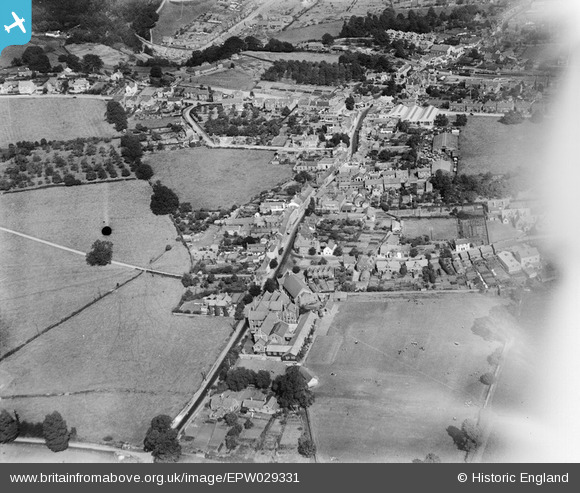
EPW029331 ENGLAND (1929). The High Street and town, Lydney, 1929
© Copyright OpenStreetMap contributors and licensed by the OpenStreetMap Foundation. 2024. Cartography is licensed as CC BY-SA.
Details
| Title | [EPW029331] The High Street and town, Lydney, 1929 |
| Reference | EPW029331 |
| Date | September-1929 |
| Link | |
| Place name | LYDNEY |
| Parish | LYDNEY |
| District | |
| Country | ENGLAND |
| Easting / Northing | 362972, 202911 |
| Longitude / Latitude | -2.5361231125854, 51.723239132386 |
| National Grid Reference | SO630029 |
Pins
 gBr |
Wednesday 17th of May 2017 03:41:56 PM | |
 gBr |
Wednesday 17th of May 2017 03:27:22 PM | |
 gBr |
Wednesday 17th of May 2017 03:25:48 PM | |
 gBr |
Wednesday 17th of May 2017 03:23:11 PM | |
 gBr |
Tuesday 9th of May 2017 09:33:29 AM | |
 gBr |
Tuesday 9th of May 2017 09:27:48 AM | |
 gBr |
Thursday 27th of November 2014 01:42:07 AM | |
 gBr |
Thursday 27th of November 2014 01:41:16 AM |


![[EPW029331] The High Street and town, Lydney, 1929](http://britainfromabove.org.uk/sites/all/libraries/aerofilms-images/public/100x100/EPW/029/EPW029331.jpg)
![[EPW029323] The town and Millrough Wood, Lydney, from the south, 1929](http://britainfromabove.org.uk/sites/all/libraries/aerofilms-images/public/100x100/EPW/029/EPW029323.jpg)
![[EPW029326] The High Street, Newerne Street and environs, Lydney, 1929](http://britainfromabove.org.uk/sites/all/libraries/aerofilms-images/public/100x100/EPW/029/EPW029326.jpg)
![[EPW029329] The town centre, Lydney, 1929](http://britainfromabove.org.uk/sites/all/libraries/aerofilms-images/public/100x100/EPW/029/EPW029329.jpg)