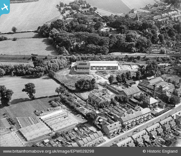
EPW028298 ENGLAND (1929). The St Bernard Cellophane Works, Old Bexley, 1929
    © Copyright OpenStreetMap contributors and licensed by the OpenStreetMap Foundation. 2025. Cartography is licensed as CC BY-SA.
  
Details
| Title | [EPW028298] The St Bernard Cellophane Works, Old Bexley, 1929 | 
| Reference | EPW028298 | 
| Date | August-1929 | 
| Link | |
| Place name | OLD BEXLEY | 
| Parish | |
| District | |
| Country | ENGLAND | 
| Easting / Northing | 549713, 173683 | 
| Longitude / Latitude | 0.15443060263985, 51.441835818438 | 
| National Grid Reference | TQ497737 | 
Pins
Be the first to add a comment to this image!
 
             
  ![[EPW028298] The St Bernard Cellophane Works, Old Bexley, 1929](http://britainfromabove.org.uk/sites/all/libraries/aerofilms-images/public/100x100/EPW/028/EPW028298.jpg) 
  
                                          ![[EPW028299] Bourne Road and Refells Brewery, Old Bexley, 1929](http://britainfromabove.org.uk/sites/all/libraries/aerofilms-images/public/100x100/EPW/028/EPW028299.jpg) 
 ![[EPW028302] Bexley High Street and Queenfisher Corn and Flour Mill, Old Bexley, 1929](http://britainfromabove.org.uk/sites/all/libraries/aerofilms-images/public/100x100/EPW/028/EPW028302.jpg) 
 ![[EPW028296] Bexley High Street and Queenfisher Corn and Flour Mill, Old Bexley, 1929](http://britainfromabove.org.uk/sites/all/libraries/aerofilms-images/public/100x100/EPW/028/EPW028296.jpg)