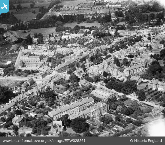
EPW028261 ENGLAND (1929). St John the Evangelist's R.C. Church and South Bar Street, Banbury, 1929
© Copyright OpenStreetMap contributors and licensed by the OpenStreetMap Foundation. 2026. Cartography is licensed as CC BY-SA.
Nearby Images (12)
Details
| Title | [EPW028261] St John the Evangelist's R.C. Church and South Bar Street, Banbury, 1929 |
| Reference | EPW028261 |
| Date | August-1929 |
| Link | |
| Place name | BANBURY |
| Parish | BANBURY |
| District | |
| Country | ENGLAND |
| Easting / Northing | 445348, 240152 |
| Longitude / Latitude | -1.3385226412355, 52.057473352206 |
| National Grid Reference | SP453402 |


![[EPW028261] St John the Evangelist's R.C. Church and South Bar Street, Banbury, 1929](http://britainfromabove.org.uk/sites/all/libraries/aerofilms-images/public/100x100/EPW/028/EPW028261.jpg)
![[EPW028260] St John the Evangelist's R.C. Church and South Bar Street, Banbury, 1929](http://britainfromabove.org.uk/sites/all/libraries/aerofilms-images/public/100x100/EPW/028/EPW028260.jpg)
![[EPW028253] The town, Banbury, from the south-west, 1929. This image has been produced from a copy-negative.](http://britainfromabove.org.uk/sites/all/libraries/aerofilms-images/public/100x100/EPW/028/EPW028253.jpg)
![[EAW006318] Cheney & Sons Ltd on Calthorpe Street and environs, Banbury, 1947](http://britainfromabove.org.uk/sites/all/libraries/aerofilms-images/public/100x100/EAW/006/EAW006318.jpg)
![[EAW006319] Cheney & Sons Ltd, the Wesleyan Methodist Chapel on Marlborough Road and environs, Banbury, 1947](http://britainfromabove.org.uk/sites/all/libraries/aerofilms-images/public/100x100/EAW/006/EAW006319.jpg)
![[EAW006321] Cheney & Sons Ltd on Calthorpe Street and environs, Banbury, 1947](http://britainfromabove.org.uk/sites/all/libraries/aerofilms-images/public/100x100/EAW/006/EAW006321.jpg)
![[EAW006316] Cheney & Sons Ltd on Calthorpe Street and environs, Banbury, 1947](http://britainfromabove.org.uk/sites/all/libraries/aerofilms-images/public/100x100/EAW/006/EAW006316.jpg)
![[EAW006320] Cheney & Sons Ltd on Calthorpe Street and environs, Banbury, 1947](http://britainfromabove.org.uk/sites/all/libraries/aerofilms-images/public/100x100/EAW/006/EAW006320.jpg)
![[EPW006004] Banbury Cross and the town centre, Banbury, 1921. This image has been produced from a copy-negative.](http://britainfromabove.org.uk/sites/all/libraries/aerofilms-images/public/100x100/EPW/006/EPW006004.jpg)
![[EAW006315] Cheney & Sons Ltd on Calthorpe Street and environs, Banbury, 1947](http://britainfromabove.org.uk/sites/all/libraries/aerofilms-images/public/100x100/EAW/006/EAW006315.jpg)
![[EAW006312] A view of the town centred upon Banbury Cross, Banbury, 1947](http://britainfromabove.org.uk/sites/all/libraries/aerofilms-images/public/100x100/EAW/006/EAW006312.jpg)
![[EAW006317] Cheney & Sons Ltd on Calthorpe Street and environs, Banbury, 1947](http://britainfromabove.org.uk/sites/all/libraries/aerofilms-images/public/100x100/EAW/006/EAW006317.jpg)

