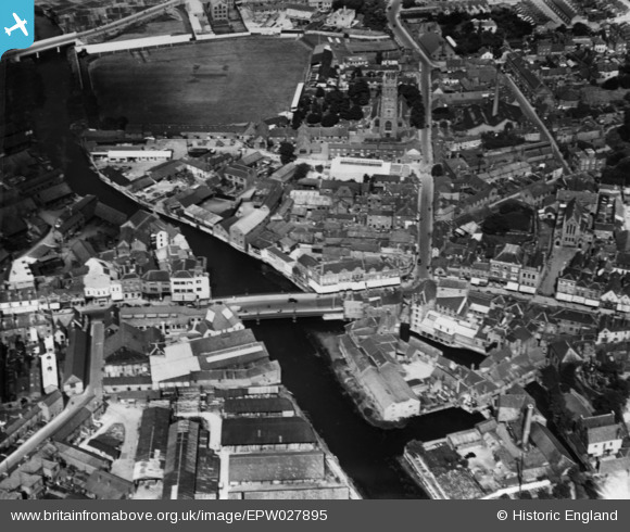
EPW027895 ENGLAND (1929). Tone Bridge, Taunton, 1929. This image has been produced from a print.
© Copyright OpenStreetMap contributors and licensed by the OpenStreetMap Foundation. 2026. Cartography is licensed as CC BY-SA.
Nearby Images (19)
Details
| Title | [EPW027895] Tone Bridge, Taunton, 1929. This image has been produced from a print. |
| Reference | EPW027895 |
| Date | 28-June-1929 |
| Link | |
| Place name | TAUNTON |
| Parish | |
| District | |
| Country | ENGLAND |
| Easting / Northing | 322698, 124812 |
| Longitude / Latitude | -3.1021663869558, 51.016943056699 |
| National Grid Reference | ST227248 |
Pins

gerry-r |
Sunday 4th of August 2024 04:31:20 PM |


![[EPW027895] Tone Bridge, Taunton, 1929. This image has been produced from a print.](http://britainfromabove.org.uk/sites/all/libraries/aerofilms-images/public/100x100/EPW/027/EPW027895.jpg)
![[EPW013543] Tone Bridge and environs, Taunton, 1925. This image has been produced from a copy-negative.](http://britainfromabove.org.uk/sites/all/libraries/aerofilms-images/public/100x100/EPW/013/EPW013543.jpg)
![[EPW027897] Tone Bridge and the town centre, 1929. This image has been produced from a copy-negative.](http://britainfromabove.org.uk/sites/all/libraries/aerofilms-images/public/100x100/EPW/027/EPW027897.jpg)
![[EAW005338] The remains of Taunton Castle and environs, Taunton, 1947. This image has been produced from a print.](http://britainfromabove.org.uk/sites/all/libraries/aerofilms-images/public/100x100/EAW/005/EAW005338.jpg)
![[EAW005339] The remains of Taunton Castle and environs, Taunton, 1947. This image has been produced from a print.](http://britainfromabove.org.uk/sites/all/libraries/aerofilms-images/public/100x100/EAW/005/EAW005339.jpg)
![[EAW005341] The remains of Taunton Castle, Taunton, 1947](http://britainfromabove.org.uk/sites/all/libraries/aerofilms-images/public/100x100/EAW/005/EAW005341.jpg)
![[EAW005337] The remains of Taunton Castle, Taunton, 1947. This image has been produced from a print.](http://britainfromabove.org.uk/sites/all/libraries/aerofilms-images/public/100x100/EAW/005/EAW005337.jpg)
![[EPW041093] North Street and excavation at the Castle Hotel, Taunton, 1933](http://britainfromabove.org.uk/sites/all/libraries/aerofilms-images/public/100x100/EPW/041/EPW041093.jpg)
![[EPW041183] Castle Green and excavation at the Castle Hotel, Taunton, 1933](http://britainfromabove.org.uk/sites/all/libraries/aerofilms-images/public/100x100/EPW/041/EPW041183.jpg)
![[EPW041094] North Street and excavation at the Castle Hotel, Taunton, 1933](http://britainfromabove.org.uk/sites/all/libraries/aerofilms-images/public/100x100/EPW/041/EPW041094.jpg)
![[EAW005342] The remains of Taunton Castle and environs, Taunton, 1947. This image has been produced from a print.](http://britainfromabove.org.uk/sites/all/libraries/aerofilms-images/public/100x100/EAW/005/EAW005342.jpg)
![[EAW005340] The remains of Taunton Castle, Taunton, 1947](http://britainfromabove.org.uk/sites/all/libraries/aerofilms-images/public/100x100/EAW/005/EAW005340.jpg)
![[EPW041184] Castle Green and the Castle Hotel, Taunton, 1933](http://britainfromabove.org.uk/sites/all/libraries/aerofilms-images/public/100x100/EPW/041/EPW041184.jpg)
![[EAW051944] The town centre, Taunton, 1953](http://britainfromabove.org.uk/sites/all/libraries/aerofilms-images/public/100x100/EAW/051/EAW051944.jpg)
![[EPW027886] North Street, the Cattle Market and the town centre, Taunton, 1929. This image has been produced from a copy-negative.](http://britainfromabove.org.uk/sites/all/libraries/aerofilms-images/public/100x100/EPW/027/EPW027886.jpg)
![[EPW027885] St Mary Magdalen's Church and the town centre, Taunton, 1929. This image has been produced from a copy-negative.](http://britainfromabove.org.uk/sites/all/libraries/aerofilms-images/public/100x100/EPW/027/EPW027885.jpg)
![[EPW027896] The junction of Staplegrove Road and Station Road, Taunton, 1929. This image has been produced from a print.](http://britainfromabove.org.uk/sites/all/libraries/aerofilms-images/public/100x100/EPW/027/EPW027896.jpg)
![[EAW005343] St Mary Magdalen's Church, Taunton, 1947](http://britainfromabove.org.uk/sites/all/libraries/aerofilms-images/public/100x100/EAW/005/EAW005343.jpg)
![[EPW013539] St Mary Magdalen's Church and East Street, Taunton, 1925. This image has been produced from a print affected by flare.](http://britainfromabove.org.uk/sites/all/libraries/aerofilms-images/public/100x100/EPW/013/EPW013539.jpg)