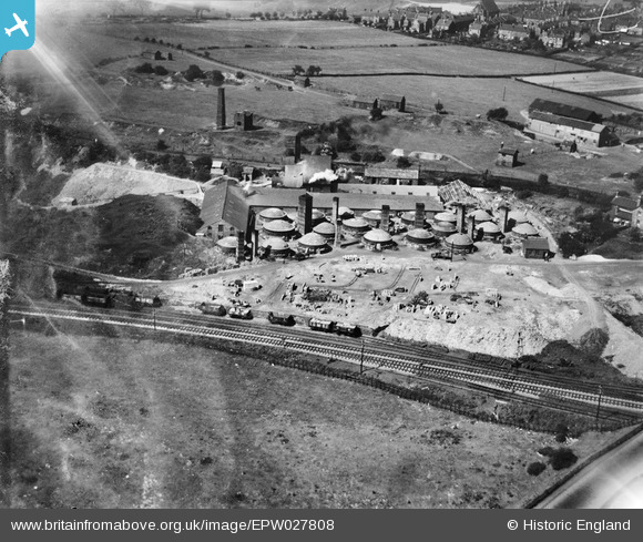
EPW027808 ENGLAND (1929). The Knutton Tileries, Silverdale, 1929
© Copyright OpenStreetMap contributors and licensed by the OpenStreetMap Foundation. 2026. Cartography is licensed as CC BY-SA.
Nearby Images (11)
Details
| Title | [EPW027808] The Knutton Tileries, Silverdale, 1929 |
| Reference | EPW027808 |
| Date | June-1929 |
| Link | |
| Place name | SILVERDALE |
| Parish | SILVERDALE |
| District | |
| Country | ENGLAND |
| Easting / Northing | 383027, 346630 |
| Longitude / Latitude | -2.2530321748588, 53.016395633855 |
| National Grid Reference | SJ830466 |
Pins

tarboat |
Friday 23rd of February 2024 05:31:14 PM | |

bescotbeast |
Saturday 1st of March 2014 02:29:58 AM | |

bescotbeast |
Saturday 1st of March 2014 02:29:10 AM | |

bescotbeast |
Saturday 1st of March 2014 02:26:08 AM | |

bescotbeast |
Saturday 1st of March 2014 02:24:44 AM | |

Martin |
Monday 30th of December 2013 04:18:54 PM |


![[EPW027808] The Knutton Tileries, Silverdale, 1929](http://britainfromabove.org.uk/sites/all/libraries/aerofilms-images/public/100x100/EPW/027/EPW027808.jpg)
![[EPW038481] The Knutton Tileries, Silverdale, 1932](http://britainfromabove.org.uk/sites/all/libraries/aerofilms-images/public/100x100/EPW/038/EPW038481.jpg)
![[EPW038480] The Knutton Tileries, Silverdale, 1932](http://britainfromabove.org.uk/sites/all/libraries/aerofilms-images/public/100x100/EPW/038/EPW038480.jpg)
![[EPW038477] The Knutton Tileries, Silverdale, 1932](http://britainfromabove.org.uk/sites/all/libraries/aerofilms-images/public/100x100/EPW/038/EPW038477.jpg)
![[EPW038476] The Knutton Tileries, Silverdale, 1932. Double-exposed negative.](http://britainfromabove.org.uk/sites/all/libraries/aerofilms-images/public/100x100/EPW/038/EPW038476.jpg)
![[EPW043652] Knutton Tileries, Newcastle-under-Lyme, 1933](http://britainfromabove.org.uk/sites/all/libraries/aerofilms-images/public/100x100/EPW/043/EPW043652.jpg)
![[EPW027807] The Knutton Tileries, Silverdale, 1929](http://britainfromabove.org.uk/sites/all/libraries/aerofilms-images/public/100x100/EPW/027/EPW027807.jpg)
![[EPW043654] Knutton Tileries, Newcastle-under-Lyme, 1933. This image has been produced from a damaged negative.](http://britainfromabove.org.uk/sites/all/libraries/aerofilms-images/public/100x100/EPW/043/EPW043654.jpg)
![[EPW043655] Knutton Tileries, Newcastle-under-Lyme, 1933](http://britainfromabove.org.uk/sites/all/libraries/aerofilms-images/public/100x100/EPW/043/EPW043655.jpg)
![[EPW038478] The Knutton Tileries and environs, Silverdale, 1932](http://britainfromabove.org.uk/sites/all/libraries/aerofilms-images/public/100x100/EPW/038/EPW038478.jpg)
![[EPW043656] Knutton Tileries, Newcastle-under-Lyme, from the south-west, 1933](http://britainfromabove.org.uk/sites/all/libraries/aerofilms-images/public/100x100/EPW/043/EPW043656.jpg)