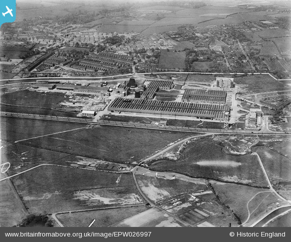
EPW026997 ENGLAND (1929). The Michelin Tyre Manufactory and environs, Boothen, 1929
© Copyright OpenStreetMap contributors and licensed by the OpenStreetMap Foundation. 2026. Cartography is licensed as CC BY-SA.
Nearby Images (40)
Details
| Title | [EPW026997] The Michelin Tyre Manufactory and environs, Boothen, 1929 |
| Reference | EPW026997 |
| Date | May-1929 |
| Link | |
| Place name | BOOTHEN |
| Parish | |
| District | |
| Country | ENGLAND |
| Easting / Northing | 387391, 343706 |
| Longitude / Latitude | -2.1878602985173, 52.990229005588 |
| National Grid Reference | SJ874437 |
Pins
Be the first to add a comment to this image!


![[EPW026997] The Michelin Tyre Manufactory and environs, Boothen, 1929](http://britainfromabove.org.uk/sites/all/libraries/aerofilms-images/public/100x100/EPW/026/EPW026997.jpg)
![[EPW019990] The Michelin Tyre Company, Trent Vale, 1927](http://britainfromabove.org.uk/sites/all/libraries/aerofilms-images/public/100x100/EPW/019/EPW019990.jpg)
![[EPW026994] The Michelin Tyre Manufactory, Boothen, 1929](http://britainfromabove.org.uk/sites/all/libraries/aerofilms-images/public/100x100/EPW/026/EPW026994.jpg)
![[EPW019995] The Michelin Tyre Company, Trent Vale, 1927](http://britainfromabove.org.uk/sites/all/libraries/aerofilms-images/public/100x100/EPW/019/EPW019995.jpg)
![[EPW019996] The Michelin Tyre Company, Trent Vale, 1927](http://britainfromabove.org.uk/sites/all/libraries/aerofilms-images/public/100x100/EPW/019/EPW019996.jpg)
![[EPW019994] The Michelin Tyre Company, Trent Vale, 1927](http://britainfromabove.org.uk/sites/all/libraries/aerofilms-images/public/100x100/EPW/019/EPW019994.jpg)
![[EPW019998] The Michelin Tyre Company, Trent Vale, 1927](http://britainfromabove.org.uk/sites/all/libraries/aerofilms-images/public/100x100/EPW/019/EPW019998.jpg)
![[EPW026991] The Michelin Tyre Manufactory, Boothen, 1929](http://britainfromabove.org.uk/sites/all/libraries/aerofilms-images/public/100x100/EPW/026/EPW026991.jpg)
![[EPW026990] The Michelin Tyre Manufactory, Boothen, 1929](http://britainfromabove.org.uk/sites/all/libraries/aerofilms-images/public/100x100/EPW/026/EPW026990.jpg)
![[EPW019993] The Michelin Tyre Company, Trent Vale, 1927](http://britainfromabove.org.uk/sites/all/libraries/aerofilms-images/public/100x100/EPW/019/EPW019993.jpg)
![[EPW019988] The Michelin Tyre Company, Trent Vale, 1927](http://britainfromabove.org.uk/sites/all/libraries/aerofilms-images/public/100x100/EPW/019/EPW019988.jpg)
![[EAW035042] The Michelin Tyre Factory, Stoke-on-Trent, 1951](http://britainfromabove.org.uk/sites/all/libraries/aerofilms-images/public/100x100/EAW/035/EAW035042.jpg)
![[EPW019991] The Michelin Tyre Company, Trent Vale, 1927](http://britainfromabove.org.uk/sites/all/libraries/aerofilms-images/public/100x100/EPW/019/EPW019991.jpg)
![[EAW035049] The Michelin Tyre Factory, Stoke-on-Trent, 1951](http://britainfromabove.org.uk/sites/all/libraries/aerofilms-images/public/100x100/EAW/035/EAW035049.jpg)
![[EAW036110] The Michelin Tyre Factory, Trent Vale, 1951. This image has been produced from a print marked by Aerofilms Ltd for photo editing.](http://britainfromabove.org.uk/sites/all/libraries/aerofilms-images/public/100x100/EAW/036/EAW036110.jpg)
![[EAW035050] The Michelin Tyre Factory, Stoke-on-Trent, 1951](http://britainfromabove.org.uk/sites/all/libraries/aerofilms-images/public/100x100/EAW/035/EAW035050.jpg)
![[EPW026998] The Michelin Tyre Manufactory and environs, Boothen, 1929](http://britainfromabove.org.uk/sites/all/libraries/aerofilms-images/public/100x100/EPW/026/EPW026998.jpg)
![[EAW036108] The Michelin Tyre Factory, Trent Vale, 1951. This image has been produced from a print marked by Aerofilms Ltd for photo editing.](http://britainfromabove.org.uk/sites/all/libraries/aerofilms-images/public/100x100/EAW/036/EAW036108.jpg)
![[EAW036111] The Michelin Tyre Factory, Trent Vale, 1951. This image has been produced from a print marked by Aerofilms Ltd for photo editing.](http://britainfromabove.org.uk/sites/all/libraries/aerofilms-images/public/100x100/EAW/036/EAW036111.jpg)
![[EPW041807] The Michelin Tyre Co Manufactury at Boothen, Stoke-on-Trent, 1933](http://britainfromabove.org.uk/sites/all/libraries/aerofilms-images/public/100x100/EPW/041/EPW041807.jpg)
![[EAW035048] The Michelin Tyre Factory, Stoke-on-Trent, 1951](http://britainfromabove.org.uk/sites/all/libraries/aerofilms-images/public/100x100/EAW/035/EAW035048.jpg)
![[EAW036112] The Michelin Tyre Factory, Trent Vale, 1951. This image has been produced from a print marked by Aerofilms Ltd for photo editing.](http://britainfromabove.org.uk/sites/all/libraries/aerofilms-images/public/100x100/EAW/036/EAW036112.jpg)
![[EAW035047] The Michelin Tyre Factory, Stoke-on-Trent, 1951](http://britainfromabove.org.uk/sites/all/libraries/aerofilms-images/public/100x100/EAW/035/EAW035047.jpg)
![[EAW036109] The Michelin Tyre Factory, Trent Vale, 1951. This image has been produced from a print marked by Aerofilms Ltd for photo editing.](http://britainfromabove.org.uk/sites/all/libraries/aerofilms-images/public/100x100/EAW/036/EAW036109.jpg)
![[EPW019989] The Michelin Tyre Company, Trent Vale, 1927](http://britainfromabove.org.uk/sites/all/libraries/aerofilms-images/public/100x100/EPW/019/EPW019989.jpg)
![[EAW036107] The Michelin Tyre Factory, Trent Vale, 1951. This image has been produced from a print marked by Aerofilms Ltd for photo editing.](http://britainfromabove.org.uk/sites/all/libraries/aerofilms-images/public/100x100/EAW/036/EAW036107.jpg)
![[EAW035044] The Michelin Tyre Factory, Stoke-on-Trent, 1951](http://britainfromabove.org.uk/sites/all/libraries/aerofilms-images/public/100x100/EAW/035/EAW035044.jpg)
![[EAW035041] The Michelin Tyre Factory, Stoke-on-Trent, 1951](http://britainfromabove.org.uk/sites/all/libraries/aerofilms-images/public/100x100/EAW/035/EAW035041.jpg)
![[EAW035045] The Michelin Tyre Factory, Stoke-on-Trent, 1951](http://britainfromabove.org.uk/sites/all/libraries/aerofilms-images/public/100x100/EAW/035/EAW035045.jpg)
![[EAW035046] The Michelin Tyre Factory, Stoke-on-Trent, 1951](http://britainfromabove.org.uk/sites/all/libraries/aerofilms-images/public/100x100/EAW/035/EAW035046.jpg)
![[EPW041808] The Michelin Tyre Co Manufactury at Boothen, Stoke-on-Trent, 1933](http://britainfromabove.org.uk/sites/all/libraries/aerofilms-images/public/100x100/EPW/041/EPW041808.jpg)
![[EAW036106] The Michelin Tyre Factory, Trent Vale, 1951. This image has been produced from a print marked by Aerofilms Ltd for photo editing.](http://britainfromabove.org.uk/sites/all/libraries/aerofilms-images/public/100x100/EAW/036/EAW036106.jpg)
![[EPW026993] The Michelin Tyre Manufactory, Boothen, 1929](http://britainfromabove.org.uk/sites/all/libraries/aerofilms-images/public/100x100/EPW/026/EPW026993.jpg)
![[EPW019992] The Michelin Tyre Company, Trent Vale, 1927](http://britainfromabove.org.uk/sites/all/libraries/aerofilms-images/public/100x100/EPW/019/EPW019992.jpg)
![[EPW026996] The Michelin Tyre Manufactory, Boothen, 1929](http://britainfromabove.org.uk/sites/all/libraries/aerofilms-images/public/100x100/EPW/026/EPW026996.jpg)
![[EPW026992] The Michelin Tyre Manufactory, Boothen, 1929](http://britainfromabove.org.uk/sites/all/libraries/aerofilms-images/public/100x100/EPW/026/EPW026992.jpg)
![[EPW019997] The Michelin Tyre Company, Trent Vale, 1927](http://britainfromabove.org.uk/sites/all/libraries/aerofilms-images/public/100x100/EPW/019/EPW019997.jpg)
![[EPW026999] The Michelin Tyre Manufactory and environs, Boothen, 1929](http://britainfromabove.org.uk/sites/all/libraries/aerofilms-images/public/100x100/EPW/026/EPW026999.jpg)
![[EAW036105] The Michelin Tyre Factory, Trent Vale, from the north-east, 1951. This image has been produced from a print marked by Aerofilms Ltd for photo editing.](http://britainfromabove.org.uk/sites/all/libraries/aerofilms-images/public/100x100/EAW/036/EAW036105.jpg)
![[EAW035043] The Michelin Tyre Factory, Stoke-on-Trent, 1951](http://britainfromabove.org.uk/sites/all/libraries/aerofilms-images/public/100x100/EAW/035/EAW035043.jpg)