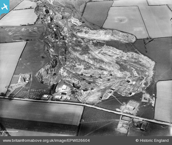
EPW026604 ENGLAND (1929). Tuthill Quarry, Haswell, 1929
© Copyright OpenStreetMap contributors and licensed by the OpenStreetMap Foundation. 2026. Cartography is licensed as CC BY-SA.
Nearby Images (10)
Details
| Title | [EPW026604] Tuthill Quarry, Haswell, 1929 |
| Reference | EPW026604 |
| Date | May-1929 |
| Link | |
| Place name | HASWELL |
| Parish | HASWELL |
| District | |
| Country | ENGLAND |
| Easting / Northing | 439075, 542371 |
| Longitude / Latitude | -1.392490256272, 54.774633728282 |
| National Grid Reference | NZ391424 |
Pins
Be the first to add a comment to this image!


![[EPW026604] Tuthill Quarry, Haswell, 1929](http://britainfromabove.org.uk/sites/all/libraries/aerofilms-images/public/100x100/EPW/026/EPW026604.jpg)
![[EPW026595] Tuthill Quarry, Haswell, 1929](http://britainfromabove.org.uk/sites/all/libraries/aerofilms-images/public/100x100/EPW/026/EPW026595.jpg)
![[EPW026596] Tuthill Quarry, Haswell, 1929](http://britainfromabove.org.uk/sites/all/libraries/aerofilms-images/public/100x100/EPW/026/EPW026596.jpg)
![[EPW026599] Tuthill Quarry, Haswell, 1929](http://britainfromabove.org.uk/sites/all/libraries/aerofilms-images/public/100x100/EPW/026/EPW026599.jpg)
![[EPW026594] Tuthill Quarry, Haswell, 1929](http://britainfromabove.org.uk/sites/all/libraries/aerofilms-images/public/100x100/EPW/026/EPW026594.jpg)
![[EPW026600] Tuthill Quarry, Haswell, 1929](http://britainfromabove.org.uk/sites/all/libraries/aerofilms-images/public/100x100/EPW/026/EPW026600.jpg)
![[EPW026601] Tuthill Quarry, Haswell, 1929](http://britainfromabove.org.uk/sites/all/libraries/aerofilms-images/public/100x100/EPW/026/EPW026601.jpg)
![[EPW026602] Tuthill Quarry, Haswell, 1929](http://britainfromabove.org.uk/sites/all/libraries/aerofilms-images/public/100x100/EPW/026/EPW026602.jpg)
![[EPW026603] Tuthill Quarry, Haswell, 1929](http://britainfromabove.org.uk/sites/all/libraries/aerofilms-images/public/100x100/EPW/026/EPW026603.jpg)
![[EPW026597] Tuthill Quarry, Haswell, 1929](http://britainfromabove.org.uk/sites/all/libraries/aerofilms-images/public/100x100/EPW/026/EPW026597.jpg)