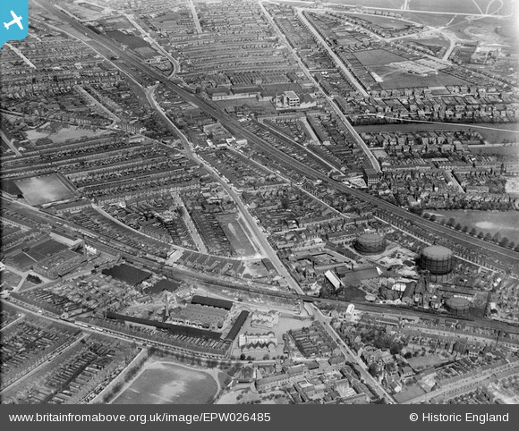
EPW026485 ENGLAND (1929). Bury Park, Luton, from the south, 1929
© Copyright OpenStreetMap contributors and licensed by the OpenStreetMap Foundation. 2026. Cartography is licensed as CC BY-SA.
Nearby Images (5)
Details
| Title | [EPW026485] Bury Park, Luton, from the south, 1929 |
| Reference | EPW026485 |
| Date | May-1929 |
| Link | |
| Place name | LUTON |
| Parish | |
| District | |
| Country | ENGLAND |
| Easting / Northing | 508438, 221594 |
| Longitude / Latitude | -0.4243785359318, 51.881911183924 |
| National Grid Reference | TL084216 |
Pins

nickmanl |
Tuesday 7th of January 2020 02:39:09 PM | |

nickmanl |
Tuesday 7th of January 2020 02:38:17 PM | |

John Wass |
Wednesday 13th of November 2019 12:13:59 PM | |

Dylan Moore |
Saturday 27th of October 2012 03:18:37 PM | |

Dylan Moore |
Saturday 27th of October 2012 03:17:25 PM | |

Dylan Moore |
Saturday 27th of October 2012 03:16:52 PM | |

Dylan Moore |
Saturday 27th of October 2012 02:46:54 PM | |

Dylan Moore |
Friday 26th of October 2012 06:08:29 PM | |

Dylan Moore |
Friday 26th of October 2012 06:08:02 PM | |

Dylan Moore |
Friday 26th of October 2012 06:07:42 PM | |

kevin_s |
Thursday 5th of July 2012 10:59:28 PM | |

Phil |
Tuesday 26th of June 2012 08:33:19 PM | |
The Luton Union Workhouse became St Marys Hospital my father was a patent in 1990. The Brute Hospital became the Grove Road Maternity Hospital I was born there in 1944 |

Owen Jones |
Saturday 9th of March 2013 08:45:02 PM |


![[EPW026485] Bury Park, Luton, from the south, 1929](http://britainfromabove.org.uk/sites/all/libraries/aerofilms-images/public/100x100/EPW/026/EPW026485.jpg)
![[EPW019226] Lyndhurst Road and environs, Luton, 1927](http://britainfromabove.org.uk/sites/all/libraries/aerofilms-images/public/100x100/EPW/019/EPW019226.jpg)
![[EPW053985] The gas works and environs, Luton, 1937](http://britainfromabove.org.uk/sites/all/libraries/aerofilms-images/public/100x100/EPW/053/EPW053985.jpg)
![[EPW037378] The Co-operative Wholesale Society Cocoa and Chocolate Works and environs, Luton, 1932](http://britainfromabove.org.uk/sites/all/libraries/aerofilms-images/public/100x100/EPW/037/EPW037378.jpg)
![[EPW005364] Cooperative Wholesale Societies Ltd Cocoa and Chocolate factory, Luton, 1921](http://britainfromabove.org.uk/sites/all/libraries/aerofilms-images/public/100x100/EPW/005/EPW005364.jpg)
