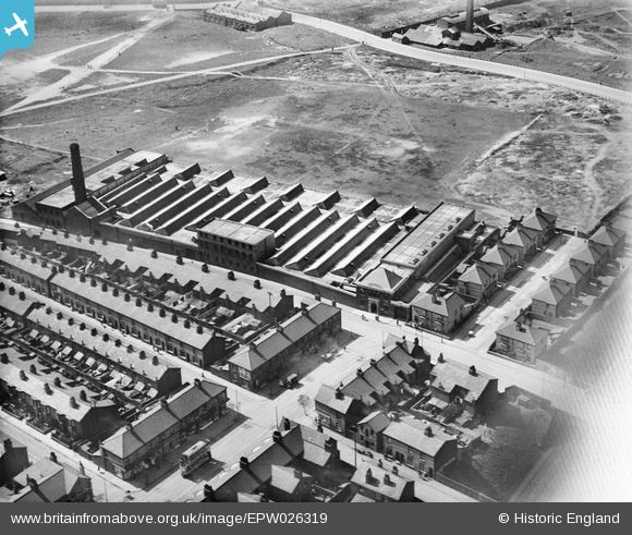
EPW026319 ENGLAND (1929). The Gandy Belt Company Wheatland Works, Seacombe, 1929
© Copyright OpenStreetMap contributors and licensed by the OpenStreetMap Foundation. 2025. Cartography is licensed as CC BY-SA.
Nearby Images (9)
Details
| Title | [EPW026319] The Gandy Belt Company Wheatland Works, Seacombe, 1929 |
| Reference | EPW026319 |
| Date | April-1929 |
| Link | |
| Place name | SEACOMBE |
| Parish | |
| District | |
| Country | ENGLAND |
| Easting / Northing | 331870, 390685 |
| Longitude / Latitude | -3.0250029741177, 53.408315696656 |
| National Grid Reference | SJ319907 |
Pins
Be the first to add a comment to this image!


![[EPW026319] The Gandy Belt Company Wheatland Works, Seacombe, 1929](http://britainfromabove.org.uk/sites/all/libraries/aerofilms-images/public/100x100/EPW/026/EPW026319.jpg)
![[EPW026318] The Gandy Belt Company Wheatland Works, Seacombe, 1929](http://britainfromabove.org.uk/sites/all/libraries/aerofilms-images/public/100x100/EPW/026/EPW026318.jpg)
![[EPW026314] The Gandy Belt Company Wheatland Works, Seacombe, 1929](http://britainfromabove.org.uk/sites/all/libraries/aerofilms-images/public/100x100/EPW/026/EPW026314.jpg)
![[EPW026315] The Gandy Belt Company Wheatland Works, Seacombe, 1929](http://britainfromabove.org.uk/sites/all/libraries/aerofilms-images/public/100x100/EPW/026/EPW026315.jpg)
![[EPW026320] The Gandy Belt Company Wheatland Works, Seacombe, 1929](http://britainfromabove.org.uk/sites/all/libraries/aerofilms-images/public/100x100/EPW/026/EPW026320.jpg)
![[EPW026313] The Gandy Belt Company Wheatland Works and environs, Seacombe, 1929](http://britainfromabove.org.uk/sites/all/libraries/aerofilms-images/public/100x100/EPW/026/EPW026313.jpg)
![[EPW026316] The Gandy Belt Company Wheatland Works, Seacombe, 1929](http://britainfromabove.org.uk/sites/all/libraries/aerofilms-images/public/100x100/EPW/026/EPW026316.jpg)
![[EPW026317] The Gandy Belt Company Wheatland Works, Seacombe, 1929](http://britainfromabove.org.uk/sites/all/libraries/aerofilms-images/public/100x100/EPW/026/EPW026317.jpg)
![[EAW038515] Buchanan's Flour Mill, the Homepride Flour Mills and environs, Seacombe, 1951. This image has been produced from a print marked by Aerofilms Ltd for photo editing.](http://britainfromabove.org.uk/sites/all/libraries/aerofilms-images/public/100x100/EAW/038/EAW038515.jpg)