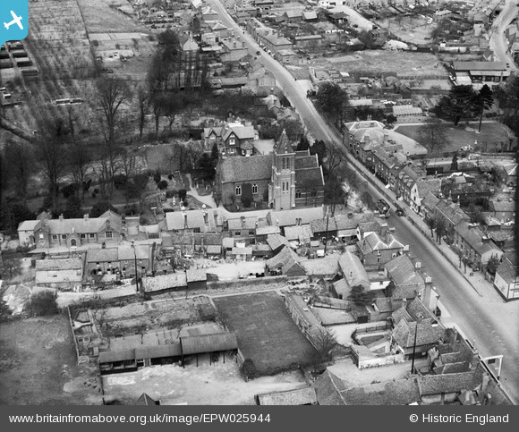
EPW025944 ENGLAND (1929). St Paul's Church, Hoddesdon, 1929
    © Copyright OpenStreetMap contributors and licensed by the OpenStreetMap Foundation. 2025. Cartography is licensed as CC BY-SA.
  
Nearby Images (6)
Details
| Title | [EPW025944] St Paul's Church, Hoddesdon, 1929 | 
| Reference | EPW025944 | 
| Date | 3-May-1929 | 
| Link | |
| Place name | HODDESDON | 
| Parish | |
| District | |
| Country | ENGLAND | 
| Easting / Northing | 537284, 208960 | 
| Longitude / Latitude | -0.010495715002076, 51.762018297288 | 
| National Grid Reference | TL373090 | 
Pins
|  An open topped bus |   SteveAUS | Friday 31st of August 2012 05:47:29 AM | 
 
             
  ![[EPW025944] St Paul's Church, Hoddesdon, 1929](http://britainfromabove.org.uk/sites/all/libraries/aerofilms-images/public/100x100/EPW/025/EPW025944.jpg) 
  
                                          ![[EPW025940] The Market Place, Hoddesdon, 1929](http://britainfromabove.org.uk/sites/all/libraries/aerofilms-images/public/100x100/EPW/025/EPW025940.jpg) 
 ![[EPW025938] The Market Place, Hoddesdon, 1929](http://britainfromabove.org.uk/sites/all/libraries/aerofilms-images/public/100x100/EPW/025/EPW025938.jpg) 
 ![[EPW013324] The town centre, Hoddesdon, 1925. This image has been produced from a copy-negative.](http://britainfromabove.org.uk/sites/all/libraries/aerofilms-images/public/100x100/EPW/013/EPW013324.jpg) 
 ![[EPW025945] The Market Place and Lord Street, Hoddesdon, 1929](http://britainfromabove.org.uk/sites/all/libraries/aerofilms-images/public/100x100/EPW/025/EPW025945.jpg) 
 ![[EPW013322] Burford Street, Hoddesdon, 1925. This image has been produced from a print.](http://britainfromabove.org.uk/sites/all/libraries/aerofilms-images/public/100x100/EPW/013/EPW013322.jpg)