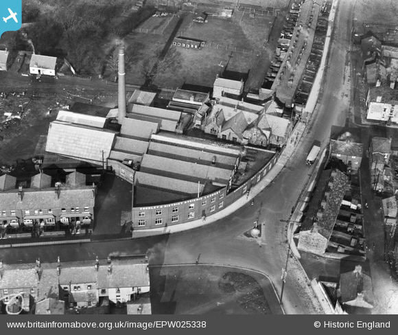
EPW025338 ENGLAND (1928). Chorley and District Hygienic Laundry, Chorley, 1928
© Copyright OpenStreetMap contributors and licensed by the OpenStreetMap Foundation. 2024. Cartography is licensed as CC BY-SA.
Nearby Images (6)
Details
| Title | [EPW025338] Chorley and District Hygienic Laundry, Chorley, 1928 |
| Reference | EPW025338 |
| Date | November-1928 |
| Link | |
| Place name | CHORLEY |
| Parish | |
| District | |
| Country | ENGLAND |
| Easting / Northing | 359180, 418551 |
| Longitude / Latitude | -2.6177993917461, 53.66161964417 |
| National Grid Reference | SD592186 |
Pins
Be the first to add a comment to this image!


![[EPW025338] Chorley and District Hygienic Laundry, Chorley, 1928](http://britainfromabove.org.uk/sites/all/libraries/aerofilms-images/public/100x100/EPW/025/EPW025338.jpg)
![[EPW025334] Chorley and District Hygienic Laundry and Thornhill Farm, Chorley, 1928](http://britainfromabove.org.uk/sites/all/libraries/aerofilms-images/public/100x100/EPW/025/EPW025334.jpg)
![[EPW025339] Chorley and District Hygienic Laundry, Chorley, 1928](http://britainfromabove.org.uk/sites/all/libraries/aerofilms-images/public/100x100/EPW/025/EPW025339.jpg)
![[EPW025337] Chorley and District Hygienic Laundry, Chorley, 1928](http://britainfromabove.org.uk/sites/all/libraries/aerofilms-images/public/100x100/EPW/025/EPW025337.jpg)
![[EPW025336] Chorley and District Hygienic Laundry and Thornhill Farm, Chorley, 1928](http://britainfromabove.org.uk/sites/all/libraries/aerofilms-images/public/100x100/EPW/025/EPW025336.jpg)
![[EPW025335] Chorley and District Hygienic Laundry and Thornhill Farm, Chorley, 1928](http://britainfromabove.org.uk/sites/all/libraries/aerofilms-images/public/100x100/EPW/025/EPW025335.jpg)