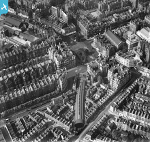
EPW024948 ENGLAND (1928). Sloane Square, Chelsea, 1928
© Copyright OpenStreetMap contributors and licensed by the OpenStreetMap Foundation. 2026. Cartography is licensed as CC BY-SA.
Nearby Images (11)
Details
| Title | [EPW024948] Sloane Square, Chelsea, 1928 |
| Reference | EPW024948 |
| Date | 6-October-1928 |
| Link | |
| Place name | CHELSEA |
| Parish | |
| District | |
| Country | ENGLAND |
| Easting / Northing | 528072, 178641 |
| Longitude / Latitude | -0.15500722198303, 51.491705831042 |
| National Grid Reference | TQ281786 |
Pins

Paivi |
Sunday 27th of July 2014 12:10:34 AM | |

Alan McFaden |
Sunday 20th of April 2014 10:14:19 AM | |

Robin |
Saturday 11th of January 2014 10:43:04 PM | |

Class31 |
Wednesday 21st of November 2012 05:11:16 PM | |

Class31 |
Wednesday 21st of November 2012 05:10:22 PM | |

Class31 |
Wednesday 21st of November 2012 05:06:06 PM | |

Class31 |
Wednesday 21st of November 2012 05:04:17 PM | |

Class31 |
Wednesday 21st of November 2012 05:03:19 PM | |

Class31 |
Wednesday 21st of November 2012 05:02:34 PM | |

Class31 |
Wednesday 21st of November 2012 05:01:31 PM | |

Class31 |
Wednesday 21st of November 2012 05:00:48 PM | |

Class31 |
Wednesday 21st of November 2012 05:00:15 PM |


![[EPW024948] Sloane Square, Chelsea, 1928](http://britainfromabove.org.uk/sites/all/libraries/aerofilms-images/public/100x100/EPW/024/EPW024948.jpg)
![[EPW046243] Sloane Square, the Duke of York's Headquarters and surroundings, Chelsea, 1934](http://britainfromabove.org.uk/sites/all/libraries/aerofilms-images/public/100x100/EPW/046/EPW046243.jpg)
![[EPW046245] Sloane Square, the Duke of York's Headquarters and surroundings, Chelsea, 1934](http://britainfromabove.org.uk/sites/all/libraries/aerofilms-images/public/100x100/EPW/046/EPW046245.jpg)
![[EPW046240] Sloane Square, the Duke of York's Headquarters and surroundings, Chelsea, 1934](http://britainfromabove.org.uk/sites/all/libraries/aerofilms-images/public/100x100/EPW/046/EPW046240.jpg)
![[EPW046244] Sloane Square, the Duke of York's Headquarters and surroundings, Chelsea, 1934](http://britainfromabove.org.uk/sites/all/libraries/aerofilms-images/public/100x100/EPW/046/EPW046244.jpg)
![[EPW046241] Sloane Square and surroundings, Chelsea, 1934](http://britainfromabove.org.uk/sites/all/libraries/aerofilms-images/public/100x100/EPW/046/EPW046241.jpg)
![[EPW046242] Sloane Square, the Duke of York's Headquarters and surroundings, Chelsea, 1934](http://britainfromabove.org.uk/sites/all/libraries/aerofilms-images/public/100x100/EPW/046/EPW046242.jpg)
![[EAW041935] King's Road by Whitelands House and the Duke of York's Headquarters, Chelsea, 1952](http://britainfromabove.org.uk/sites/all/libraries/aerofilms-images/public/100x100/EAW/041/EAW041935.jpg)
![[EPW006507] Chelsea, Belgravia and Buckingham Palace, Chelsea, 1921. This image has been produced from a copy-negative.](http://britainfromabove.org.uk/sites/all/libraries/aerofilms-images/public/100x100/EPW/006/EPW006507.jpg)
![[EPW024248] The Duke of York's Headquarters and environs, Chelsea, 1928](http://britainfromabove.org.uk/sites/all/libraries/aerofilms-images/public/100x100/EPW/024/EPW024248.jpg)
![[EPW006309] View of Belgravia and Buckingham Palace, Westminster, from the south-west, 1921](http://britainfromabove.org.uk/sites/all/libraries/aerofilms-images/public/100x100/EPW/006/EPW006309.jpg)

