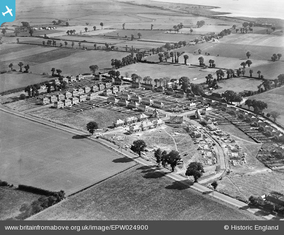
EPW024900 ENGLAND (1928). New housing under construction between Corringham Road and Billet Lane, Stanford-le-Hope, 1928
© Copyright OpenStreetMap contributors and licensed by the OpenStreetMap Foundation. 2026. Cartography is licensed as CC BY-SA.
Nearby Images (5)
Details
| Title | [EPW024900] New housing under construction between Corringham Road and Billet Lane, Stanford-le-Hope, 1928 |
| Reference | EPW024900 |
| Date | 3-October-1928 |
| Link | |
| Place name | STANFORD-LE-HOPE |
| Parish | |
| District | |
| Country | ENGLAND |
| Easting / Northing | 569358, 182415 |
| Longitude / Latitude | 0.44105751183526, 51.51475423911 |
| National Grid Reference | TQ694824 |
Pins

Corringham Light Railway |
Tuesday 17th of December 2024 08:02:00 PM | |

Corringham Light Railway |
Thursday 4th of August 2022 11:16:42 AM | |

Bandon |
Friday 15th of January 2021 04:38:09 PM | |

Bandon |
Friday 27th of November 2020 04:51:50 PM | |

Ferina |
Saturday 28th of June 2014 04:29:11 PM | |

BigglesH |
Monday 16th of July 2012 09:07:12 PM | |

BigglesH |
Monday 16th of July 2012 09:06:07 PM | |

BigglesH |
Monday 16th of July 2012 09:05:15 PM |
User Comment Contributions
Photo taken from Northwest. See also EPW024903 & EPW024905. |

BigglesH |
Monday 16th of July 2012 09:34:48 PM |


![[EPW024900] New housing under construction between Corringham Road and Billet Lane, Stanford-le-Hope, 1928](http://britainfromabove.org.uk/sites/all/libraries/aerofilms-images/public/100x100/EPW/024/EPW024900.jpg)
![[EPW024903] Ivywall Farm and new housing under construction between Corringham Road and Billet Lane, Stanford-le-Hope, 1928](http://britainfromabove.org.uk/sites/all/libraries/aerofilms-images/public/100x100/EPW/024/EPW024903.jpg)
![[EPW024905] New housing under construction between Corringham Road and Billet Lane, Stanford-le-Hope, 1928](http://britainfromabove.org.uk/sites/all/libraries/aerofilms-images/public/100x100/EPW/024/EPW024905.jpg)
![[EAW024610] The town and Shell Haven Oil Refinery, Stanford-le-Hope, from the west, 1949. This image has been produced from a damaged negative.](http://britainfromabove.org.uk/sites/all/libraries/aerofilms-images/public/100x100/EAW/024/EAW024610.jpg)
![[EAW024611] The town and Shell Haven Oil Refinery, Stanford-le-Hope, from the west, 1949](http://britainfromabove.org.uk/sites/all/libraries/aerofilms-images/public/100x100/EAW/024/EAW024611.jpg)