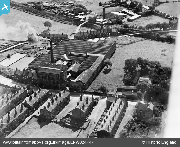
EPW024447 ENGLAND (1928). The Leafield Woollen Mills, Yeadon, 1928
© Copyright OpenStreetMap contributors and licensed by the OpenStreetMap Foundation. 2026. Cartography is licensed as CC BY-SA.
Nearby Images (22)
Details
| Title | [EPW024447] The Leafield Woollen Mills, Yeadon, 1928 |
| Reference | EPW024447 |
| Date | September-1928 |
| Link | |
| Place name | YEADON |
| Parish | |
| District | |
| Country | ENGLAND |
| Easting / Northing | 420113, 441110 |
| Longitude / Latitude | -1.694117711621, 53.865607757527 |
| National Grid Reference | SE201411 |
Pins

potty01926 |
Saturday 4th of May 2013 09:10:58 AM | |

Lootz |
Sunday 1st of July 2012 10:24:25 PM |


![[EPW024447] The Leafield Woollen Mills, Yeadon, 1928](http://britainfromabove.org.uk/sites/all/libraries/aerofilms-images/public/100x100/EPW/024/EPW024447.jpg)
![[EAW036909] James Ives and Co Ltd Leafield Woollen Mills, Yeadon, 1951. This image has been produced from a print marked by Aerofilms Ltd for photo editing.](http://britainfromabove.org.uk/sites/all/libraries/aerofilms-images/public/100x100/EAW/036/EAW036909.jpg)
![[EAW008883] The Leafield Woollen Mills, Yeadon, 1947](http://britainfromabove.org.uk/sites/all/libraries/aerofilms-images/public/100x100/EAW/008/EAW008883.jpg)
![[EAW036907] James Ives and Co Ltd Leafield Woollen Mills, Yeadon, 1951. This image has been produced from a print marked by Aerofilms Ltd for photo editing.](http://britainfromabove.org.uk/sites/all/libraries/aerofilms-images/public/100x100/EAW/036/EAW036907.jpg)
![[EAW008881] The Leafield Woollen Mills and environs, Yeadon, 1947. This image was marked by Aerofilms Ltd for photo editing.](http://britainfromabove.org.uk/sites/all/libraries/aerofilms-images/public/100x100/EAW/008/EAW008881.jpg)
![[EPW024446] The Leafield Woollen Mills, Yeadon, 1928](http://britainfromabove.org.uk/sites/all/libraries/aerofilms-images/public/100x100/EPW/024/EPW024446.jpg)
![[EAW008885] Leafield, the Leafield Woollen Mills and environs, Yeadon, 1947](http://britainfromabove.org.uk/sites/all/libraries/aerofilms-images/public/100x100/EAW/008/EAW008885.jpg)
![[EAW008877] The Leafield Woollen Mills, Yeadon, 1947](http://britainfromabove.org.uk/sites/all/libraries/aerofilms-images/public/100x100/EAW/008/EAW008877.jpg)
![[EAW036910] James Ives and Co Ltd Leafield Woollen Mills, Yeadon, 1951. This image has been produced from a print marked by Aerofilms Ltd for photo editing.](http://britainfromabove.org.uk/sites/all/libraries/aerofilms-images/public/100x100/EAW/036/EAW036910.jpg)
![[EAW036904] James Ives and Co Ltd Leafield Woollen Mills, Yeadon, 1951. This image has been produced from a print marked by Aerofilms Ltd for photo editing.](http://britainfromabove.org.uk/sites/all/libraries/aerofilms-images/public/100x100/EAW/036/EAW036904.jpg)
![[EAW036908] James Ives and Co Ltd Leafield Woollen Mills, Yeadon, 1951. This image has been produced from a print marked by Aerofilms Ltd for photo editing.](http://britainfromabove.org.uk/sites/all/libraries/aerofilms-images/public/100x100/EAW/036/EAW036908.jpg)
![[EAW036906] James Ives and Co Ltd Leafield Woollen Mills, Yeadon, 1951. This image has been produced from a print marked by Aerofilms Ltd for photo editing.](http://britainfromabove.org.uk/sites/all/libraries/aerofilms-images/public/100x100/EAW/036/EAW036906.jpg)
![[EAW008879] The Leafield Woollen Mills, Yeadon, 1947](http://britainfromabove.org.uk/sites/all/libraries/aerofilms-images/public/100x100/EAW/008/EAW008879.jpg)
![[EAW008884] The Leafield Woollen Mills, Yeadon, 1947. This image was marked by Aerofilms Ltd for photo editing.](http://britainfromabove.org.uk/sites/all/libraries/aerofilms-images/public/100x100/EAW/008/EAW008884.jpg)
![[EAW008882] Leafield, the Leafield Woollen Mills and environs, Yeadon, 1947. This image was marked by Aerofilms Ltd for photo editing.](http://britainfromabove.org.uk/sites/all/libraries/aerofilms-images/public/100x100/EAW/008/EAW008882.jpg)
![[EAW008878] The Leafield Woollen Mills, Yeadon, 1947](http://britainfromabove.org.uk/sites/all/libraries/aerofilms-images/public/100x100/EAW/008/EAW008878.jpg)
![[EAW036905] James Ives and Co Ltd Leafield Woollen Mills, Yeadon, 1951. This image has been produced from a print marked by Aerofilms Ltd for photo editing.](http://britainfromabove.org.uk/sites/all/libraries/aerofilms-images/public/100x100/EAW/036/EAW036905.jpg)
![[EAW008880] The Leafield Woollen Mills and environs, Yeadon, 1947. This image was marked by Aerofilms Ltd for photo editing.](http://britainfromabove.org.uk/sites/all/libraries/aerofilms-images/public/100x100/EAW/008/EAW008880.jpg)
![[EAW036912] James Ives and Co Ltd Leafield Woollen Mills and environs, Yeadon, 1951. This image has been produced from a print marked by Aerofilms Ltd for photo editing.](http://britainfromabove.org.uk/sites/all/libraries/aerofilms-images/public/100x100/EAW/036/EAW036912.jpg)
![[EAW036911] James Ives and Co Ltd Leafield Woollen Mills and environs, Yeadon, 1951. This image has been produced from a print marked by Aerofilms Ltd for photo editing.](http://britainfromabove.org.uk/sites/all/libraries/aerofilms-images/public/100x100/EAW/036/EAW036911.jpg)
![[EPW024449] Kirk Lane Mills, Yeadon, 1928](http://britainfromabove.org.uk/sites/all/libraries/aerofilms-images/public/100x100/EPW/024/EPW024449.jpg)
![[EPW024445] Kirk Lane Mills, Yeadon, 1928](http://britainfromabove.org.uk/sites/all/libraries/aerofilms-images/public/100x100/EPW/024/EPW024445.jpg)