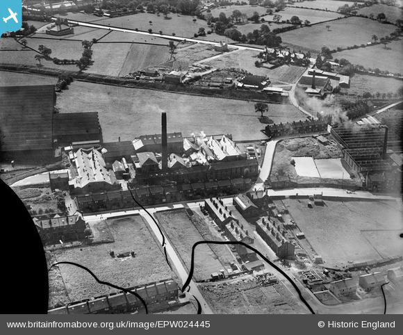
EPW024445 ENGLAND (1928). Kirk Lane Mills, Yeadon, 1928
© Copyright OpenStreetMap contributors and licensed by the OpenStreetMap Foundation. 2026. Cartography is licensed as CC BY-SA.
Nearby Images (26)
Details
| Title | [EPW024445] Kirk Lane Mills, Yeadon, 1928 |
| Reference | EPW024445 |
| Date | September-1928 |
| Link | |
| Place name | YEADON |
| Parish | |
| District | |
| Country | ENGLAND |
| Easting / Northing | 420297, 441076 |
| Longitude / Latitude | -1.6913216993938, 53.865294975023 |
| National Grid Reference | SE203411 |
Pins

Andy Bodkin |
Tuesday 9th of September 2014 09:44:53 PM | |

Andy Bodkin |
Monday 8th of September 2014 04:38:55 PM | |

Sandy |
Thursday 5th of July 2012 07:36:27 PM |


![[EPW024445] Kirk Lane Mills, Yeadon, 1928](http://britainfromabove.org.uk/sites/all/libraries/aerofilms-images/public/100x100/EPW/024/EPW024445.jpg)
![[EPW024449] Kirk Lane Mills, Yeadon, 1928](http://britainfromabove.org.uk/sites/all/libraries/aerofilms-images/public/100x100/EPW/024/EPW024449.jpg)
![[EAW036905] James Ives and Co Ltd Leafield Woollen Mills, Yeadon, 1951. This image has been produced from a print marked by Aerofilms Ltd for photo editing.](http://britainfromabove.org.uk/sites/all/libraries/aerofilms-images/public/100x100/EAW/036/EAW036905.jpg)
![[EAW008878] The Leafield Woollen Mills, Yeadon, 1947](http://britainfromabove.org.uk/sites/all/libraries/aerofilms-images/public/100x100/EAW/008/EAW008878.jpg)
![[EAW008879] The Leafield Woollen Mills, Yeadon, 1947](http://britainfromabove.org.uk/sites/all/libraries/aerofilms-images/public/100x100/EAW/008/EAW008879.jpg)
![[EAW036906] James Ives and Co Ltd Leafield Woollen Mills, Yeadon, 1951. This image has been produced from a print marked by Aerofilms Ltd for photo editing.](http://britainfromabove.org.uk/sites/all/libraries/aerofilms-images/public/100x100/EAW/036/EAW036906.jpg)
![[EAW036910] James Ives and Co Ltd Leafield Woollen Mills, Yeadon, 1951. This image has been produced from a print marked by Aerofilms Ltd for photo editing.](http://britainfromabove.org.uk/sites/all/libraries/aerofilms-images/public/100x100/EAW/036/EAW036910.jpg)
![[EAW008877] The Leafield Woollen Mills, Yeadon, 1947](http://britainfromabove.org.uk/sites/all/libraries/aerofilms-images/public/100x100/EAW/008/EAW008877.jpg)
![[EAW036904] James Ives and Co Ltd Leafield Woollen Mills, Yeadon, 1951. This image has been produced from a print marked by Aerofilms Ltd for photo editing.](http://britainfromabove.org.uk/sites/all/libraries/aerofilms-images/public/100x100/EAW/036/EAW036904.jpg)
![[EAW036907] James Ives and Co Ltd Leafield Woollen Mills, Yeadon, 1951. This image has been produced from a print marked by Aerofilms Ltd for photo editing.](http://britainfromabove.org.uk/sites/all/libraries/aerofilms-images/public/100x100/EAW/036/EAW036907.jpg)
![[EAW008883] The Leafield Woollen Mills, Yeadon, 1947](http://britainfromabove.org.uk/sites/all/libraries/aerofilms-images/public/100x100/EAW/008/EAW008883.jpg)
![[EAW036908] James Ives and Co Ltd Leafield Woollen Mills, Yeadon, 1951. This image has been produced from a print marked by Aerofilms Ltd for photo editing.](http://britainfromabove.org.uk/sites/all/libraries/aerofilms-images/public/100x100/EAW/036/EAW036908.jpg)
![[EAW008882] Leafield, the Leafield Woollen Mills and environs, Yeadon, 1947. This image was marked by Aerofilms Ltd for photo editing.](http://britainfromabove.org.uk/sites/all/libraries/aerofilms-images/public/100x100/EAW/008/EAW008882.jpg)
![[EPW024446] The Leafield Woollen Mills, Yeadon, 1928](http://britainfromabove.org.uk/sites/all/libraries/aerofilms-images/public/100x100/EPW/024/EPW024446.jpg)
![[EAW008884] The Leafield Woollen Mills, Yeadon, 1947. This image was marked by Aerofilms Ltd for photo editing.](http://britainfromabove.org.uk/sites/all/libraries/aerofilms-images/public/100x100/EAW/008/EAW008884.jpg)
![[EPW024447] The Leafield Woollen Mills, Yeadon, 1928](http://britainfromabove.org.uk/sites/all/libraries/aerofilms-images/public/100x100/EPW/024/EPW024447.jpg)
![[EAW036909] James Ives and Co Ltd Leafield Woollen Mills, Yeadon, 1951. This image has been produced from a print marked by Aerofilms Ltd for photo editing.](http://britainfromabove.org.uk/sites/all/libraries/aerofilms-images/public/100x100/EAW/036/EAW036909.jpg)
![[EAW008881] The Leafield Woollen Mills and environs, Yeadon, 1947. This image was marked by Aerofilms Ltd for photo editing.](http://britainfromabove.org.uk/sites/all/libraries/aerofilms-images/public/100x100/EAW/008/EAW008881.jpg)
![[EAW008885] Leafield, the Leafield Woollen Mills and environs, Yeadon, 1947](http://britainfromabove.org.uk/sites/all/libraries/aerofilms-images/public/100x100/EAW/008/EAW008885.jpg)
![[EAW036903] James Ives and Co Ltd Manor Woollen Mills, Yeadon, 1951. This image has been produced from a print marked by Aerofilms Ltd for photo editing.](http://britainfromabove.org.uk/sites/all/libraries/aerofilms-images/public/100x100/EAW/036/EAW036903.jpg)
![[EAW008880] The Leafield Woollen Mills and environs, Yeadon, 1947. This image was marked by Aerofilms Ltd for photo editing.](http://britainfromabove.org.uk/sites/all/libraries/aerofilms-images/public/100x100/EAW/008/EAW008880.jpg)
![[EAW036897] James Ives and Co Ltd Manor Woollen Mills, Yeadon, 1951. This image has been produced from a print marked by Aerofilms Ltd for photo editing.](http://britainfromabove.org.uk/sites/all/libraries/aerofilms-images/public/100x100/EAW/036/EAW036897.jpg)
![[EAW036899] James Ives and Co Ltd Manor Woollen Mills, Yeadon, 1951. This image has been produced from a print marked by Aerofilms Ltd for photo editing.](http://britainfromabove.org.uk/sites/all/libraries/aerofilms-images/public/100x100/EAW/036/EAW036899.jpg)
![[EAW036900] James Ives and Co Ltd Manor Woollen Mills, Yeadon, 1951. This image has been produced from a print marked by Aerofilms Ltd for photo editing.](http://britainfromabove.org.uk/sites/all/libraries/aerofilms-images/public/100x100/EAW/036/EAW036900.jpg)
![[EAW008869] Manor Woollen Mills and environs, Yeadon, 1947](http://britainfromabove.org.uk/sites/all/libraries/aerofilms-images/public/100x100/EAW/008/EAW008869.jpg)
![[EAW036901] James Ives and Co Ltd Manor Woollen Mills, Yeadon, 1951. This image has been produced from a print marked by Aerofilms Ltd for photo editing.](http://britainfromabove.org.uk/sites/all/libraries/aerofilms-images/public/100x100/EAW/036/EAW036901.jpg)
