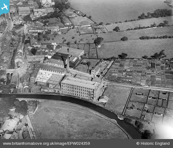
EPW024359 ENGLAND (1928). The Waterloo Worsted Mills, Silsden, 1928
© Copyright OpenStreetMap contributors and licensed by the OpenStreetMap Foundation. 2025. Cartography is licensed as CC BY-SA.
Nearby Images (5)
Details
| Title | [EPW024359] The Waterloo Worsted Mills, Silsden, 1928 |
| Reference | EPW024359 |
| Date | September-1928 |
| Link | |
| Place name | SILSDEN |
| Parish | SILSDEN |
| District | |
| Country | ENGLAND |
| Easting / Northing | 404330, 446204 |
| Longitude / Latitude | -1.9340760401914, 53.911768764926 |
| National Grid Reference | SE043462 |
Pins
Be the first to add a comment to this image!
User Comment Contributions
Ended up as one of the last steam powered mills in the country,closing in the 1970s. At the time this picture was taken, it was run by JT Taylor of Steeton. |

Phil |
Tuesday 26th of June 2012 11:44:19 PM |


![[EPW024359] The Waterloo Worsted Mills, Silsden, 1928](http://britainfromabove.org.uk/sites/all/libraries/aerofilms-images/public/100x100/EPW/024/EPW024359.jpg)
![[EPW024354] Mills on the Leeds and Liverpool Canal, Silsden, 1928](http://britainfromabove.org.uk/sites/all/libraries/aerofilms-images/public/100x100/EPW/024/EPW024354.jpg)
![[EPW024353] Kirkgate and environs, Silsden, 1928](http://britainfromabove.org.uk/sites/all/libraries/aerofilms-images/public/100x100/EPW/024/EPW024353.jpg)
![[EPW024356] The John Knox Cotton Mill (Airedale Shed) and environs, Silsden, 1928](http://britainfromabove.org.uk/sites/all/libraries/aerofilms-images/public/100x100/EPW/024/EPW024356.jpg)
![[EPW024358] The John Knox Cotton Mill (Airedale Shed) and St James's Church, Silsden, 1928](http://britainfromabove.org.uk/sites/all/libraries/aerofilms-images/public/100x100/EPW/024/EPW024358.jpg)