
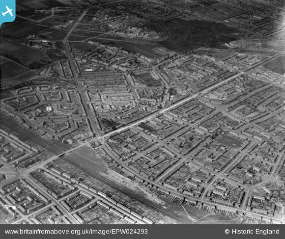
EPW024293 ENGLAND (1928). Housing surrounding Heathway, Becontree, 1928
© Copyright OpenStreetMap contributors and licensed by the OpenStreetMap Foundation. 2026. Cartography is licensed as CC BY-SA.
Nearby Images (2)
EPW024293

EPW024298

Details
| Title | [EPW024293] Housing surrounding Heathway, Becontree, 1928 |
| Reference | EPW024293 |
| Date | September-1928 |
| Link | |
| Place name | BECONTREE |
| Parish | |
| District | |
| Country | ENGLAND |
| Easting / Northing | 549005, 185117 |
| Longitude / Latitude | 0.14907805587628, 51.544770751141 |
| National Grid Reference | TQ490851 |
Pins

Ken Stanton |
Sunday 9th of May 2021 05:39:50 PM | |
|
Ken Stanton |
Sunday 9th of May 2021 05:38:56 PM | |
|
Ken Stanton |
Sunday 9th of May 2021 05:38:15 PM | |
|
steve _b |
Saturday 30th of June 2012 05:47:09 PM |
User Comment Contributions
Running diagonally from top right to bottom left of this picture is Heathway. From the bottom right curving around to meet Heathway is Reede Road. Turning left from reede Road along Heathway is a bridge over the railway line. This is where Dagenham Heathway station is now. When I left Dagenham in 1972 the area of Heathway around the station was still known as 'the bridge'. Across Heathway from Reede Road is Parsloes Avenue with Parsloes Park on the left. Parsloes Avenue meets Porters Avenue and Wood Lane at Martin's Corner. Valence Circus (a circular road) can be seen at the top of the picture. |
Ken Stanton |
Saturday 30th of June 2012 06:05:05 PM |
Running diagonally from top right to bottom left of this picture is Heathway. From the bottom right curving around to meet Heathway is Reede Road. Turning left from reede Road along Heathway is a bridge over the railway line. This is where Dagenham Heathway station is now. When I left Dagenham in 1972 the area of Heathway around the station was still known as 'the bridge'. Across Heathway from Reede Road is Parsloes Avenue with Parsloes Park on the left. Parsloes Avenue meets Porters Avenue and Wood Lane at Martin's Corner. Valence Circus (a circular road) can be seen at the top of the picture. |
Ken Stanton |
Saturday 30th of June 2012 06:03:48 PM |