
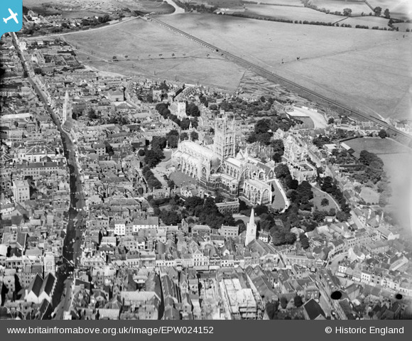
EPW024152 ENGLAND (1928). Holy Trinity Catheral and environs, Gloucester, 1928
© Copyright OpenStreetMap contributors and licensed by the OpenStreetMap Foundation. 2026. Cartography is licensed as CC BY-SA.
Nearby Images (27)
EPW024152

EAW000730

EPW024155

EAW003565

EPW006011

EAW003569

EPW041487

EAW003567

EPW024158

EPW024163

EAW003566

EAW003568

EPW024165

EAW032304

EAW032305

EAW032306

EPW024170

EAW032303

EAW000727

EAW000731

EAW018729

EAW012147

EAW000726

EAW000729

EPW024169

EPW037835

EPW024106

Details
| Title | [EPW024152] Holy Trinity Catheral and environs, Gloucester, 1928 |
| Reference | EPW024152 |
| Date | September-1928 |
| Link | |
| Place name | GLOUCESTER |
| Parish | |
| District | |
| Country | ENGLAND |
| Easting / Northing | 383117, 218757 |
| Longitude / Latitude | -2.2452227505342, 51.866694589082 |
| National Grid Reference | SO831188 |
Pins

Class31 |
Tuesday 16th of October 2012 02:20:01 PM | |
|
Class31 |
Tuesday 16th of October 2012 02:15:22 PM | |
|
Class31 |
Tuesday 16th of October 2012 02:14:14 PM | |
|
Class31 |
Tuesday 16th of October 2012 02:13:49 PM | |
|
Class31 |
Tuesday 16th of October 2012 02:13:26 PM | |
|
Class31 |
Tuesday 16th of October 2012 02:12:52 PM | |
|
Class31 |
Tuesday 16th of October 2012 02:12:25 PM | |

gannett |
Saturday 7th of July 2012 02:09:39 PM | |
|
gannett |
Saturday 7th of July 2012 02:07:30 PM |
User Comment Contributions
Shows: * st oswalds priory ??? Is that an extant building, constructed around the current medieval ruin? * the oxbode lane, pre widening * st aldates (partial view) * st Michaels c19th nave * pattern of gate street, lane, lane, small street along north gate st from cross to gate site at hare lane * the old westgate bridge; westgate st continuing from cross to bridge, uninterrupted by ring rd |
Ian Williams |
Saturday 30th of June 2012 10:38:24 AM |