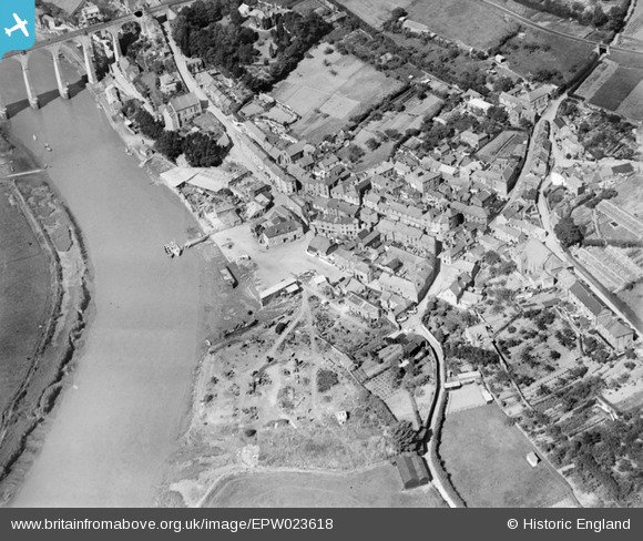
EPW023618 ENGLAND (1928). The village centre, Calstock, 1928
© Copyright OpenStreetMap contributors and licensed by the OpenStreetMap Foundation. 2026. Cartography is licensed as CC BY-SA.
Details
| Title | [EPW023618] The village centre, Calstock, 1928 |
| Reference | EPW023618 |
| Date | September-1928 |
| Link | |
| Place name | CALSTOCK |
| Parish | CALSTOCK |
| District | |
| Country | ENGLAND |
| Easting / Northing | 243623, 68562 |
| Longitude / Latitude | -4.2050430361543, 50.495362595609 |
| National Grid Reference | SX436686 |
Pins

MB |
Tuesday 11th of September 2012 09:24:03 AM | |

MB |
Tuesday 11th of September 2012 09:22:50 AM | |

MB |
Tuesday 11th of September 2012 09:21:02 AM | |

MB |
Tuesday 11th of September 2012 09:19:35 AM | |

MB |
Tuesday 11th of September 2012 09:15:21 AM | |
This was a chapel and now a beautiful conversion to the home of the publisher Peterloopoets |

robsmorgan |
Saturday 26th of April 2014 10:12:03 AM |

MB |
Tuesday 11th of September 2012 09:13:41 AM | |

MB |
Tuesday 11th of September 2012 09:12:48 AM | |

MB |
Tuesday 11th of September 2012 09:11:43 AM | |

MB |
Tuesday 11th of September 2012 09:10:58 AM |


![[EPW023618] The village centre, Calstock, 1928](http://britainfromabove.org.uk/sites/all/libraries/aerofilms-images/public/100x100/EPW/023/EPW023618.jpg)
![[EPW023617] The village, Calstock, 1928](http://britainfromabove.org.uk/sites/all/libraries/aerofilms-images/public/100x100/EPW/023/EPW023617.jpg)
![[EPW023619] The village and railway viaduct over the River Tamar, Calstock, 1928](http://britainfromabove.org.uk/sites/all/libraries/aerofilms-images/public/100x100/EPW/023/EPW023619.jpg)
![[EPW023620] The village and railway viaduct over the River Tamar, Calstock, 1928](http://britainfromabove.org.uk/sites/all/libraries/aerofilms-images/public/100x100/EPW/023/EPW023620.jpg)