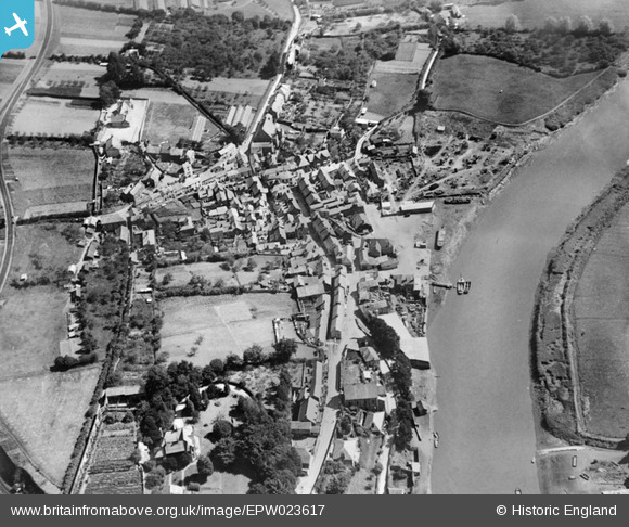
EPW023617 ENGLAND (1928). The village, Calstock, 1928
© Copyright OpenStreetMap contributors and licensed by the OpenStreetMap Foundation. 2026. Cartography is licensed as CC BY-SA.
Details
| Title | [EPW023617] The village, Calstock, 1928 |
| Reference | EPW023617 |
| Date | September-1928 |
| Link | |
| Place name | CALSTOCK |
| Parish | CALSTOCK |
| District | |
| Country | ENGLAND |
| Easting / Northing | 243612, 68604 |
| Longitude / Latitude | -4.2052156050451, 50.495737128749 |
| National Grid Reference | SX436686 |
Pins

Athalia |
Friday 1st of January 2016 11:10:49 AM | |

MB |
Tuesday 11th of September 2012 09:31:01 AM | |

MB |
Tuesday 11th of September 2012 09:30:05 AM | |

MB |
Tuesday 11th of September 2012 09:29:00 AM | |

MB |
Tuesday 11th of September 2012 09:28:36 AM | |

MB |
Tuesday 11th of September 2012 09:28:05 AM | |

MB |
Tuesday 11th of September 2012 09:27:35 AM | |

MB |
Tuesday 11th of September 2012 09:26:55 AM | |

MB |
Tuesday 11th of September 2012 09:26:23 AM | |

MB |
Tuesday 11th of September 2012 09:25:51 AM |


![[EPW023617] The village, Calstock, 1928](http://britainfromabove.org.uk/sites/all/libraries/aerofilms-images/public/100x100/EPW/023/EPW023617.jpg)
![[EPW023618] The village centre, Calstock, 1928](http://britainfromabove.org.uk/sites/all/libraries/aerofilms-images/public/100x100/EPW/023/EPW023618.jpg)
![[EPW023619] The village and railway viaduct over the River Tamar, Calstock, 1928](http://britainfromabove.org.uk/sites/all/libraries/aerofilms-images/public/100x100/EPW/023/EPW023619.jpg)
![[EPW023620] The village and railway viaduct over the River Tamar, Calstock, 1928](http://britainfromabove.org.uk/sites/all/libraries/aerofilms-images/public/100x100/EPW/023/EPW023620.jpg)