
EPW022763 ENGLAND (1928). The Thornycrofts Motor Works, Basingstoke, 1928

© Copyright OpenStreetMap contributors and licensed by the OpenStreetMap Foundation. 2026. Cartography is licensed as CC BY-SA.
Nearby Images (9)
EPW022763

EPW011145

EPW062432

EPW062435

EPW022761

EPW062436

EPW062431

EPW062434

EPW062430

Details
| Title | [EPW022763] The Thornycrofts Motor Works, Basingstoke, 1928 |
| Reference | EPW022763 |
| Date | August-1928 |
| Link | |
| Place name | BASINGSTOKE |
| Parish | |
| District | |
| Country | ENGLAND |
| Easting / Northing | 462499, 151961 |
| Longitude / Latitude | -1.104150354569, 51.262865941336 |
| National Grid Reference | SU625520 |
Pins

TJSmith |
Friday 23rd of August 2024 05:20:55 PM | |
|
Michael Woolf |
Thursday 18th of March 2021 07:06:55 PM | |
|
MB |
Thursday 23rd of January 2014 09:50:39 PM | |
|
MB |
Tuesday 23rd of October 2012 11:06:49 AM | |
|
Mark Herriott |
Wednesday 27th of June 2012 11:24:05 PM | |
|
Mark Herriott |
Wednesday 27th of June 2012 11:22:04 PM | |
|
Mark Herriott |
Wednesday 27th of June 2012 11:21:17 PM | |
|
Mark Herriott |
Wednesday 27th of June 2012 11:20:11 PM |
User Comment Contributions
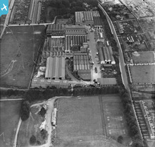
basingstoke and alton light railway (lswr) running horizontally with sidings to thorneycroft motor works and railway wagons in yard. |
David |
Sunday 5th of August 2012 01:07:10 PM |