
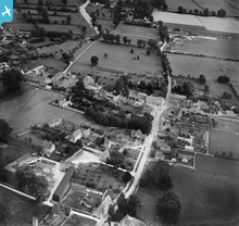
EPW022425 ENGLAND (1928). Milton End, Fairford, 1928

© Copyright OpenStreetMap contributors and licensed by the OpenStreetMap Foundation. 2026. Cartography is licensed as CC BY-SA.
Nearby Images (2)
EPW022425

EPW022419

Details
| Title | [EPW022425] Milton End, Fairford, 1928 |
| Reference | EPW022425 |
| Date | 11-August-1928 |
| Link | |
| Place name | FAIRFORD |
| Parish | FAIRFORD |
| District | |
| Country | ENGLAND |
| Easting / Northing | 414791, 200997 |
| Longitude / Latitude | -1.7859202586851, 51.707056006862 |
| National Grid Reference | SP148010 |
Pins
Lynda Tubbs |
Tuesday 18th of June 2013 02:08:17 PM |
User Comment Contributions
Milton End |
Hefin Meara |
Tuesday 22nd of January 2013 11:36:17 AM |