
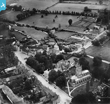
EPW022420 ENGLAND (1928). St Mary's Church and High Street, Fairford, 1928

© Copyright OpenStreetMap contributors and licensed by the OpenStreetMap Foundation. 2026. Cartography is licensed as CC BY-SA.
Nearby Images (4)
EPW022420

EPW022422

EPW022419

EPW022423

Details
| Title | [EPW022420] St Mary's Church and High Street, Fairford, 1928 |
| Reference | EPW022420 |
| Date | August-1928 |
| Link | |
| Place name | FAIRFORD |
| Parish | FAIRFORD |
| District | |
| Country | ENGLAND |
| Easting / Northing | 415133, 201045 |
| Longitude / Latitude | -1.7809682248488, 51.707478506067 |
| National Grid Reference | SP151010 |
Pins
Be the first to add a comment to this image!
User Comment Contributions
St Mary's Church and High Street, Fairford |
Hefin Meara |
Tuesday 22nd of January 2013 11:42:47 AM |