
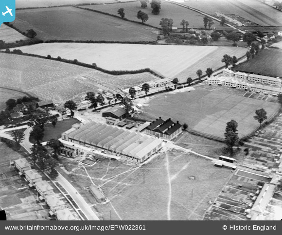
EPW022361 ENGLAND (1928). The Crittall Manufacturing Co Ltd Works, Silver End, 1928
© Copyright OpenStreetMap contributors and licensed by the OpenStreetMap Foundation. 2026. Cartography is licensed as CC BY-SA.
Nearby Images (7)
EPW022361

EAW018553

EAW018555

EAW018556

EAW018561

EAW018557

EAW018558

Details
| Title | [EPW022361] The Crittall Manufacturing Co Ltd Works, Silver End, 1928 |
| Reference | EPW022361 |
| Date | August-1928 |
| Link | |
| Place name | SILVER END |
| Parish | SILVER END |
| District | |
| Country | ENGLAND |
| Easting / Northing | 581027, 219588 |
| Longitude / Latitude | 0.62834156488185, 51.845054486573 |
| National Grid Reference | TL810196 |
Pins
 |

NikkiBunny |
Tuesday 22nd of July 2014 10:12:08 AM |

Class31 |
Sunday 16th of December 2012 10:46:48 AM | |
|
Class31 |
Sunday 16th of December 2012 10:45:28 AM | |
|
Class31 |
Sunday 16th of December 2012 10:44:46 AM | |
|
Class31 |
Sunday 16th of December 2012 10:43:12 AM | |
|
Billiken |
Thursday 20th of September 2012 05:49:31 PM | |
|
BigglesH |
Sunday 29th of July 2012 03:54:18 AM | |
no, but similar EPWO 16662 |
dave43 |
Wednesday 1st of August 2012 08:03:04 PM |
Back in the 50s we would collect the hay into small piles for lifting onto the hay cart with pitchforks - in later years it was left in rows for the mechanical collector. |
Billiken |
Thursday 20th of September 2012 05:40:11 PM |
|
BigglesH |
Sunday 29th of July 2012 03:34:48 AM | |
It looks pretty typical for a small electrical generator plant. The period of these photos was before the National Grid had been completed, and it wasn't unusual for factories to generate their own electricity. |
Snaptophobic |
Wednesday 15th of August 2012 10:56:26 AM |
This was the power station for Silver End. It still stands today :) |
NikkiBunny |
Tuesday 22nd of July 2014 10:06:21 AM |
|
BigglesH |
Sunday 29th of July 2012 03:26:32 AM | |
|
BigglesH |
Sunday 29th of July 2012 03:17:14 AM | |
|
BigglesH |
Sunday 29th of July 2012 03:15:31 AM | |
|
Paolo |
Thursday 19th of July 2012 05:18:07 PM |
User Comment Contributions
The triangular road junction at centre left is at 51.846599, 0.636301. The photo is taken looking east. The road from the bottom left to centre edge is Temple Lane going up to meet Western Road which crosses the centre of the photo. The houses 2/3 up to right are School Road. In 2009 Google Earth showed a closed (formerly laird hardware) complex where an (see Google Streetview) agent Fenn Wright (tel: 01245 26126) was offering storage. |
|
Tuesday 26th of February 2013 03:06:43 PM |
Silver End was a model village conceived by Francis Henry Crittall situated between Braintree and Witham in Essex. |
Class31 |
Wednesday 2nd of January 2013 11:36:08 AM |
Thanks for all the input on this one! The original Aerofilms Ltd Register entry is "cancelled", so not much help to us as I'm sure you can understand... Yours, Katy Britain from Above Cataloguing Team Leader |
Katy Whitaker |
Wednesday 2nd of January 2013 11:36:08 AM |
Well done Jonathan for getting this one which has eluded us for the past six months. View is looking south east. All the roads fit for Silver End. The factory has a Laird sign on Google but looks to be close to demolition. I wonder what the history is here. |
Class31 |
Sunday 16th of December 2012 03:10:36 PM |
State of back gardens (bottom right of photo) suggests well established housing to right (but out of) of photo. Vague shadows suggest photo taken from south-west (50% confidence). |
BigglesH |
Sunday 29th of July 2012 03:33:05 AM |