
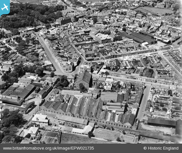
EPW021735 ENGLAND (1928). The Cross and the town, Camborne, 1928
© Copyright OpenStreetMap contributors and licensed by the OpenStreetMap Foundation. 2026. Cartography is licensed as CC BY-SA.
Nearby Images (20)
EPW021735

EPW009888

EAW027857

EAW027858

EPW009934

EAW027859

EPW009886

EAW027860

EPW039770

EPW009889

EPW021736

EAW033645

EPW009933

EPW021738

EPW009887

EAW033646

EPW059670

EPW021737

EPW021739

EPW059671

Details
| Title | [EPW021735] The Cross and the town, Camborne, 1928 |
| Reference | EPW021735 |
| Date | 24-June-1928 |
| Link | |
| Place name | CAMBORNE |
| Parish | CAMBORNE |
| District | |
| Country | ENGLAND |
| Easting / Northing | 164831, 39834 |
| Longitude / Latitude | -5.2965055388773, 50.211082355264 |
| National Grid Reference | SW648398 |
Pins

Tracie |
Wednesday 24th of February 2021 11:59:17 AM | |
|
cornishirishmaid |
Monday 10th of August 2015 08:44:57 AM | |
|
cornishirishmaid |
Monday 10th of August 2015 08:43:57 AM | |
|
cornishirishmaid |
Monday 10th of August 2015 08:43:04 AM | |
|
cornishirishmaid |
Monday 10th of August 2015 08:42:16 AM | |
|
cornishirishmaid |
Monday 10th of August 2015 08:41:42 AM | |
|
cornishirishmaid |
Monday 10th of August 2015 08:41:09 AM | |
|
cornishirishmaid |
Monday 10th of August 2015 08:40:27 AM | |

Class31 |
Saturday 18th of April 2015 07:26:54 PM | |

clippedwings |
Tuesday 2nd of December 2014 04:42:57 PM | |
|
clippedwings |
Tuesday 2nd of December 2014 04:36:57 PM | |
|
Class31 |
Tuesday 2nd of December 2014 12:45:13 PM |


User Comment Contributions

Trevu Road, Camborne, 15/04/2015 |
Class31 |
Saturday 18th of April 2015 07:27:49 PM |