
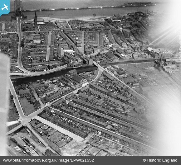
EPW021652 ENGLAND (1928). Doctor's Bridge and the town, Runcorn, 1928
© Copyright OpenStreetMap contributors and licensed by the OpenStreetMap Foundation. 2026. Cartography is licensed as CC BY-SA.
Nearby Images (7)
EPW021652

EPW018912

EPW018918

EPW021653

EAW023480

EAW021995

EAW021990

Details
| Title | [EPW021652] Doctor's Bridge and the town, Runcorn, 1928 |
| Reference | EPW021652 |
| Date | June-1928 |
| Link | |
| Place name | RUNCORN |
| Parish | |
| District | |
| Country | ENGLAND |
| Easting / Northing | 351074, 382834 |
| Longitude / Latitude | -2.7348978189568, 53.339873978232 |
| National Grid Reference | SJ511828 |
Pins

Sprinch Boatyard Research |
Tuesday 29th of July 2025 12:25:56 PM | |
|
Bottom Yard |
Monday 12th of May 2025 04:44:31 PM | |
|
Bottom Yard |
Monday 12th of May 2025 04:41:33 PM | |
|
Bottom Yard |
Tuesday 8th of October 2024 08:58:28 AM | |

Ginger79 |
Wednesday 18th of March 2020 06:56:44 AM | |
|
Bottom Yard |
Thursday 10th of January 2019 04:25:29 PM | |
|
Bottom Yard |
Thursday 10th of January 2019 04:24:25 PM | |
|
Watchman |
Tuesday 27th of June 2017 12:27:02 AM | |
|
Watchman |
Tuesday 27th of June 2017 12:26:33 AM | |

Class31 |
Sunday 31st of May 2015 09:11:07 PM | |
|
Class31 |
Wednesday 1st of May 2013 05:08:47 PM | |
|
Class31 |
Wednesday 1st of May 2013 05:06:30 PM | |
|
Class31 |
Wednesday 1st of May 2013 05:05:28 PM | |
|
Class31 |
Wednesday 1st of May 2013 05:04:29 PM |

User Comment Contributions
You can just make out the Widnes - Runcorn Transporter Bridge across the river Maersay and the Manchester Ship Canal. |
Frank S |
Saturday 30th of June 2012 11:23:22 AM |