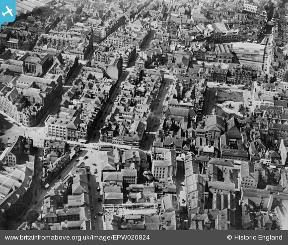
EPW020824 ENGLAND (1928). Belvoir Street, Town Hall Square and environs, Leicester, 1928. This image has been produced from a copy-negative.
© Copyright OpenStreetMap contributors and licensed by the OpenStreetMap Foundation. 2026. Cartography is licensed as CC BY-SA.
Nearby Images (25)
Details
| Title | [EPW020824] Belvoir Street, Town Hall Square and environs, Leicester, 1928. This image has been produced from a copy-negative. |
| Reference | EPW020824 |
| Date | April-1928 |
| Link | |
| Place name | LEICESTER |
| Parish | |
| District | |
| Country | ENGLAND |
| Easting / Northing | 458788, 304241 |
| Longitude / Latitude | -1.131277715951, 52.632382607426 |
| National Grid Reference | SK588042 |


![[EPW020824] Belvoir Street, Town Hall Square and environs, Leicester, 1928. This image has been produced from a copy-negative.](http://britainfromabove.org.uk/sites/all/libraries/aerofilms-images/public/100x100/EPW/020/EPW020824.jpg)
![[EPW020819] Belvoir Street and environs, Leicester, 1928](http://britainfromabove.org.uk/sites/all/libraries/aerofilms-images/public/100x100/EPW/020/EPW020819.jpg)
![[EPW020817] Belvoir Street and environs, Leicester, 1928](http://britainfromabove.org.uk/sites/all/libraries/aerofilms-images/public/100x100/EPW/020/EPW020817.jpg)
![[EPW020822] Belvoir Street and environs, Leicester, 1928. This image has been produced from a copy-negative.](http://britainfromabove.org.uk/sites/all/libraries/aerofilms-images/public/100x100/EPW/020/EPW020822.jpg)
![[EPW020815] Market Street and environs, Leicester, 1928](http://britainfromabove.org.uk/sites/all/libraries/aerofilms-images/public/100x100/EPW/020/EPW020815.jpg)
![[EPW020816] Welford Place and environs, Leicester, 1928](http://britainfromabove.org.uk/sites/all/libraries/aerofilms-images/public/100x100/EPW/020/EPW020816.jpg)
![[EAW024241] The city centre, Leicester, 1949](http://britainfromabove.org.uk/sites/all/libraries/aerofilms-images/public/100x100/EAW/024/EAW024241.jpg)
![[EPW018415] Welford Place and environs, Leicester, 1927. This image has been produced from a print.](http://britainfromabove.org.uk/sites/all/libraries/aerofilms-images/public/100x100/EPW/018/EPW018415.jpg)
![[EPW018461] Welford Place and Newarke Street, Leicester, 1927. This image has been produced from a print.](http://britainfromabove.org.uk/sites/all/libraries/aerofilms-images/public/100x100/EPW/018/EPW018461.jpg)
![[EPW020825] Welford Place, Leicester, 1928. This image has been produced from a print.](http://britainfromabove.org.uk/sites/all/libraries/aerofilms-images/public/100x100/EPW/020/EPW020825.jpg)
![[EPW020826] Welford Place and environs, Leicester, 1928. This image has been produced from a print.](http://britainfromabove.org.uk/sites/all/libraries/aerofilms-images/public/100x100/EPW/020/EPW020826.jpg)
![[EPW020814] Pocklingtons Walk and environs, Leicester, 1928](http://britainfromabove.org.uk/sites/all/libraries/aerofilms-images/public/100x100/EPW/020/EPW020814.jpg)
![[EPW020818] Pocklingtons Walk and environs, Leicester, 1928](http://britainfromabove.org.uk/sites/all/libraries/aerofilms-images/public/100x100/EPW/020/EPW020818.jpg)
![[EPW055010] The city centre, Leicester, from the south-west, 1937](http://britainfromabove.org.uk/sites/all/libraries/aerofilms-images/public/100x100/EPW/055/EPW055010.jpg)
![[EPW047868] Bishop Street and environs, Leicester, 1935](http://britainfromabove.org.uk/sites/all/libraries/aerofilms-images/public/100x100/EPW/047/EPW047868.jpg)
![[EAW051830] The city centre, Leicester, from the west, 1953](http://britainfromabove.org.uk/sites/all/libraries/aerofilms-images/public/100x100/EAW/051/EAW051830.jpg)
![[EPW018421] The Town Hall, Horsefair Street and environs, Leicester, 1927. This image has been produced from a print.](http://britainfromabove.org.uk/sites/all/libraries/aerofilms-images/public/100x100/EPW/018/EPW018421.jpg)
![[EPW020892] The Town Square and city centre, Leicester, 1928](http://britainfromabove.org.uk/sites/all/libraries/aerofilms-images/public/100x100/EPW/020/EPW020892.jpg)
![[EAW051828] The city, Leicester, from the west, 1953](http://britainfromabove.org.uk/sites/all/libraries/aerofilms-images/public/100x100/EAW/051/EAW051828.jpg)
![[EPW018436] Town Hall Square and environs, Leicester, 1927](http://britainfromabove.org.uk/sites/all/libraries/aerofilms-images/public/100x100/EPW/018/EPW018436.jpg)
![[EPW061211] The city centre, Leicester, 1939](http://britainfromabove.org.uk/sites/all/libraries/aerofilms-images/public/100x100/EPW/061/EPW061211.jpg)
![[EPW018431] The junction of Gallowtree Gate and Halford Street, Leicester, 1927](http://britainfromabove.org.uk/sites/all/libraries/aerofilms-images/public/100x100/EPW/018/EPW018431.jpg)
![[EAW024240] Charles Street, Granby Street and the city centre, Leicester, 1949](http://britainfromabove.org.uk/sites/all/libraries/aerofilms-images/public/100x100/EAW/024/EAW024240.jpg)
![[EPW047642] The city centre, Leicester, from the south-west, 1935](http://britainfromabove.org.uk/sites/all/libraries/aerofilms-images/public/100x100/EPW/047/EPW047642.jpg)
![[EPW055002] The city around Belvoir Street and Granby Street, Leicester, 1937](http://britainfromabove.org.uk/sites/all/libraries/aerofilms-images/public/100x100/EPW/055/EPW055002.jpg)
