
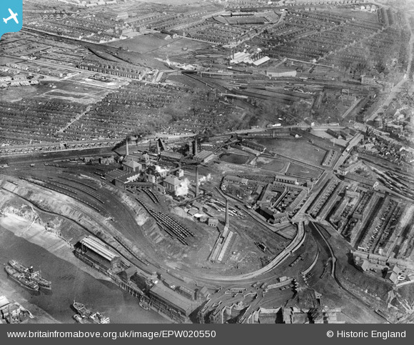
EPW020550 ENGLAND (1928). The Wearmouth Colliery, Sunderland, 1928
© Copyright OpenStreetMap contributors and licensed by the OpenStreetMap Foundation. 2026. Cartography is licensed as CC BY-SA.
Nearby Images (7)
EPW020550

EPW020549

EPW020548

EPW020552

EPW020553

EPW020551

EPW020547

Details
| Title | [EPW020550] The Wearmouth Colliery, Sunderland, 1928 |
| Reference | EPW020550 |
| Date | March-1928 |
| Link | |
| Place name | SUNDERLAND |
| Parish | |
| District | |
| Country | ENGLAND |
| Easting / Northing | 439364, 558000 |
| Longitude / Latitude | -1.3858680046447, 54.915067946367 |
| National Grid Reference | NZ394580 |
Pins

joel |
Sunday 21st of August 2016 07:46:48 PM | |
|
joel |
Sunday 21st of August 2016 07:31:35 PM | |
|
joel |
Sunday 21st of August 2016 07:22:41 PM | |
|
joel |
Sunday 21st of August 2016 07:19:29 PM | |
|
joel |
Sunday 21st of August 2016 07:09:57 PM | |
|
joel |
Sunday 21st of August 2016 07:07:33 PM | |
|
Brian |
Wednesday 7th of August 2013 02:14:00 PM | |
|
Chells809 |
Tuesday 6th of November 2012 09:24:55 PM | |
|
Chells809 |
Tuesday 6th of November 2012 09:24:54 PM | |
|
kevin_s |
Monday 9th of July 2012 09:38:45 PM |


User Comment Contributions
Coal mining was still a major industry in England in the 1920s. This image shows a very large colliery with not only the chimneys, shafts and buildings but also the means to transport the coal to where it was needed, in this case both a railway and the River Wear. |
MM |
Thursday 21st of March 2013 10:40:15 AM |
The Stadium of Light ground of Sunderland Football Club now stands on the site of the old Wearmouth Colliery which closed in 1993. The pit worked seams of coal under the North Sea. |
Chells809 |
Tuesday 6th of November 2012 09:27:06 PM |
|
Sunderland AFC, Roker Park 1928. |
kevin_s |
Monday 9th of July 2012 09:40:10 PM |