
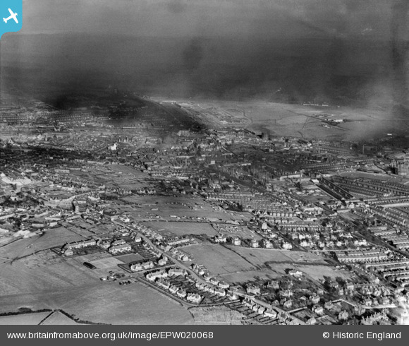
EPW020068 ENGLAND (1927). The Potteries, Stoke-On-Trent, from the south-west, 1927
© Copyright OpenStreetMap contributors and licensed by the OpenStreetMap Foundation. 2026. Cartography is licensed as CC BY-SA.
Nearby Images (3)
EPW020068

EPW020011

EAW038495

Details
| Title | [EPW020068] The Potteries, Stoke-On-Trent, from the south-west, 1927 |
| Reference | EPW020068 |
| Date | November-1927 |
| Link | |
| Place name | STOKE-ON-TRENT |
| Parish | |
| District | |
| Country | ENGLAND |
| Easting / Northing | 387092, 344987 |
| Longitude / Latitude | -2.1923662163604, 53.001738295659 |
| National Grid Reference | SJ871450 |
Pins

GB |
Thursday 14th of September 2023 03:42:52 PM | |
|
GB |
Thursday 14th of September 2023 03:41:57 PM | |
|
MsAliB |
Friday 13th of November 2020 05:16:41 PM | |
|
MsAliB |
Friday 13th of November 2020 05:08:12 PM | |

cidge |
Tuesday 31st of July 2018 11:26:22 PM | |

Class31 |
Monday 1st of June 2015 08:18:12 AM | |
|
AlecMcAulay |
Tuesday 1st of October 2013 01:46:39 AM | |

bescotbeast |
Monday 16th of September 2013 12:52:16 AM | |
|
Andreww |
Friday 19th of October 2012 05:32:04 PM | |
|
Pots64 |
Tuesday 3rd of July 2012 07:34:29 PM | |
|
Pots64 |
Tuesday 3rd of July 2012 07:33:15 PM | |
|
Pots64 |
Tuesday 3rd of July 2012 12:44:10 PM | |
|
Pots64 |
Tuesday 3rd of July 2012 12:43:12 PM |

User Comment Contributions
The road in the foreground running NW-SW is Trentham Road (renamed as Trent Valley Road), Penkhull. The Villas at Stokeville can be clearly seen in a line running down the hill towards London Road. |
Pots64 |
Tuesday 3rd of July 2012 12:40:42 PM |