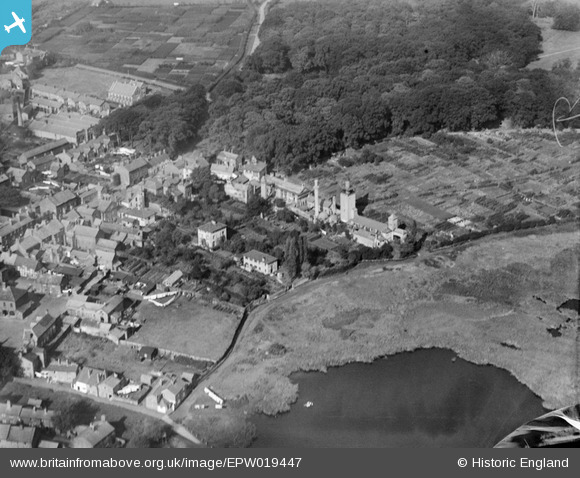
EPW019447 ENGLAND (1927). Laundry at Drury Lane and environs, Knutsford, 1927
© Copyright OpenStreetMap contributors and licensed by the OpenStreetMap Foundation. 2025. Cartography is licensed as CC BY-SA.
Nearby Images (5)
Details
| Title | [EPW019447] Laundry at Drury Lane and environs, Knutsford, 1927 |
| Reference | EPW019447 |
| Date | October-1927 |
| Link | |
| Place name | KNUTSFORD |
| Parish | KNUTSFORD |
| District | |
| Country | ENGLAND |
| Easting / Northing | 375244, 378919 |
| Longitude / Latitude | -2.3715565606833, 53.306363388273 |
| National Grid Reference | SJ752789 |
Pins

Ian Warburton |
Saturday 27th of December 2014 06:29:00 PM | |

Ian Warburton |
Saturday 27th of December 2014 06:27:34 PM | |

GinnyC |
Sunday 31st of March 2013 08:00:57 PM | |

GinnyC |
Sunday 31st of March 2013 07:59:10 PM | |

GinnyC |
Sunday 31st of March 2013 07:58:46 PM |


![[EPW019447] Laundry at Drury Lane and environs, Knutsford, 1927](http://britainfromabove.org.uk/sites/all/libraries/aerofilms-images/public/100x100/EPW/019/EPW019447.jpg)
![[EAW050495] Manchester Road, the bowling green and environs, Knutsford, 1953](http://britainfromabove.org.uk/sites/all/libraries/aerofilms-images/public/100x100/EAW/050/EAW050495.jpg)
![[EPW019446] Old Market Place, Knutsford, 1927](http://britainfromabove.org.uk/sites/all/libraries/aerofilms-images/public/100x100/EPW/019/EPW019446.jpg)
![[EAW050497] King Street and the surrounding town, Knutsford, 1953](http://britainfromabove.org.uk/sites/all/libraries/aerofilms-images/public/100x100/EAW/050/EAW050497.jpg)
![[EPW019445] The junction of Tatton Street, Princess Street and Canute Place, Knutsford, 1927](http://britainfromabove.org.uk/sites/all/libraries/aerofilms-images/public/100x100/EPW/019/EPW019445.jpg)