
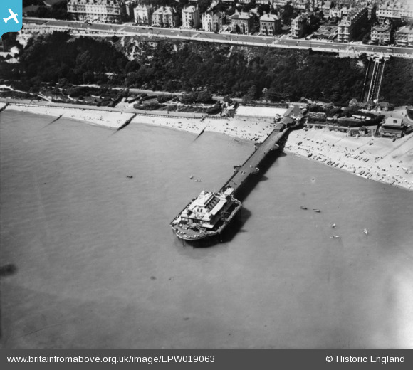
EPW019063 ENGLAND (1927). Victoria Pier, Folkestone, 1927. This image has been produced from a print.
© Copyright OpenStreetMap contributors and licensed by the OpenStreetMap Foundation. 2026. Cartography is licensed as CC BY-SA.
Nearby Images (14)
EPW019063

EPW000582

EPW009195

EPW042868

EAW024825

EPW000362

EPW009202

EPW000080

EPW035409

EPW009200

EPW019064

EAW002851

EPW000587

EPW042870

Details
| Title | [EPW019063] Victoria Pier, Folkestone, 1927. This image has been produced from a print. |
| Reference | EPW019063 |
| Date | 3-August-1927 |
| Link | |
| Place name | FOLKESTONE |
| Parish | FOLKESTONE |
| District | |
| Country | ENGLAND |
| Easting / Northing | 622744, 135481 |
| Longitude / Latitude | 1.1801302288209, 51.074820742315 |
| National Grid Reference | TR227355 |
Pins
Be the first to add a comment to this image!
User Comment Contributions
The pier was breached in WW2, as many piers were. The pavilion was destroyed by fire in 1945, and the remains of the pier demolished in 1954. |

John W |
Wednesday 12th of October 2016 10:25:31 AM |