
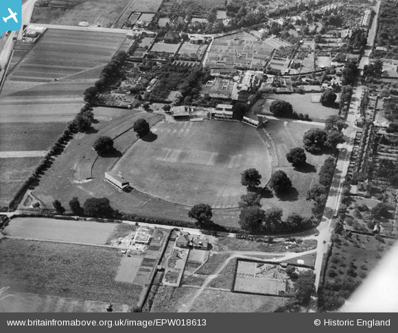
EPW018613 ENGLAND (1927). Cricket match in progress at the County Cricket Ground (St Lawrence Ground), Canterbury, 1927
© Copyright OpenStreetMap contributors and licensed by the OpenStreetMap Foundation. 2026. Cartography is licensed as CC BY-SA.
Nearby Images (13)
EPW018613
, Canterbury, 1927")
EPW018614
, Canterbury, 1927")
EPW018610
, Canterbury, 1927")
EPW038145

EAW031807

EAW031806

EPW018611
, Canterbury, 1927")
EAW014339
, Canterbury, 1948. This image has been produced from a print.")
EAW014340
, Canterbury, from the south-east, 1948. This image has been produced from a print.")
EAW014337
, Canterbury, 1948. This image has been produced from a print.")
EAW014338
, Canterbury, 1948. This image has been produced from a print.")
EAW031805

EAW014341
, Canterbury, from the north-east, 1948. This image has been produced from a print.")
Details
| Title | [EPW018613] Cricket match in progress at the County Cricket Ground (St Lawrence Ground), Canterbury, 1927 |
| Reference | EPW018613 |
| Date | 22-June-1927 |
| Link | |
| Place name | CANTERBURY |
| Parish | |
| District | |
| Country | ENGLAND |
| Easting / Northing | 615768, 156566 |
| Longitude / Latitude | 1.0933444720381, 51.266828283683 |
| National Grid Reference | TR158566 |
Pins
David Parry |
Friday 3rd of May 2013 06:56:39 PM | |
The original 200 year old lime tree had to be removed after storm damage in 2005. Another tree had meanwhile been planted outside the boundary in 1999 - it was moved onto the field of play in 2005. |
David Parry |
Friday 3rd of May 2013 07:00:54 PM |

MB |
Saturday 12th of January 2013 10:36:22 AM | |
|
rorykehoe |
Monday 6th of August 2012 06:26:12 PM |
User Comment Contributions

The eccentric Canterbury cricket ground with a tree growing to maturity within the field of play. |
David Parry |
Tuesday 14th of May 2013 06:45:09 PM |