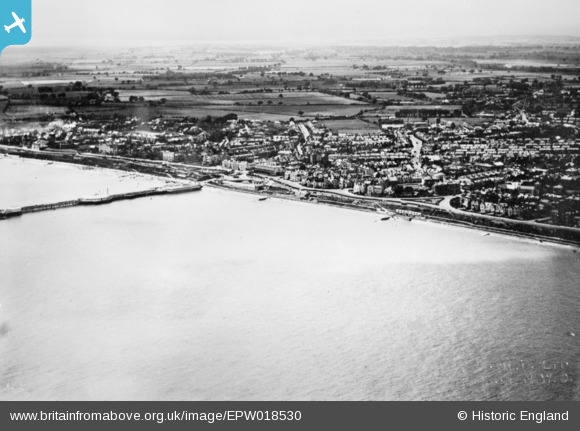
EPW018530 ENGLAND (1927). The town, Clacton-On-Sea, from the south-east, 1927. This image has been produced from a copy-negative.
© Copyright OpenStreetMap contributors and licensed by the OpenStreetMap Foundation. 2026. Cartography is licensed as CC BY-SA.
Nearby Images (31)
Details
| Title | [EPW018530] The town, Clacton-On-Sea, from the south-east, 1927. This image has been produced from a copy-negative. |
| Reference | EPW018530 |
| Date | 20-June-1927 |
| Link | |
| Place name | CLACTON-ON-SEA |
| Parish | |
| District | |
| Country | ENGLAND |
| Easting / Northing | 618054, 214455 |
| Longitude / Latitude | 1.1618988830275, 51.785739023336 |
| National Grid Reference | TM181145 |
Pins
Be the first to add a comment to this image!


![[EPW018530] The town, Clacton-On-Sea, from the south-east, 1927. This image has been produced from a copy-negative.](http://britainfromabove.org.uk/sites/all/libraries/aerofilms-images/public/100x100/EPW/018/EPW018530.jpg)
![[EPW039131] The pier and the town, Clacton-on-Sea, from the south-east, 1932](http://britainfromabove.org.uk/sites/all/libraries/aerofilms-images/public/100x100/EPW/039/EPW039131.jpg)
![[EPW049015] The pier and the town, Clacton-On-Sea, from the north-east, 1935. This image has been produced from a print.](http://britainfromabove.org.uk/sites/all/libraries/aerofilms-images/public/100x100/EPW/049/EPW049015.jpg)
![[EPW039132] The pier and the town, Clacton-on-Sea, from the south-east, 1932](http://britainfromabove.org.uk/sites/all/libraries/aerofilms-images/public/100x100/EPW/039/EPW039132.jpg)
![[EPW039127] The pier and the town, Clacton-on-Sea, from the south-east, 1932](http://britainfromabove.org.uk/sites/all/libraries/aerofilms-images/public/100x100/EPW/039/EPW039127.jpg)
![[EAW043671] Marine Parade East and the town, Clacton-On-Sea, from the south-east, 1952](http://britainfromabove.org.uk/sites/all/libraries/aerofilms-images/public/100x100/EAW/043/EAW043671.jpg)
![[EPW039133] The pier and the town, Clacton-on-Sea, from the south-east, 1932](http://britainfromabove.org.uk/sites/all/libraries/aerofilms-images/public/100x100/EPW/039/EPW039133.jpg)
![[EPW039136] Marine Parade East and the pier, Clacton-on-Sea, 1932](http://britainfromabove.org.uk/sites/all/libraries/aerofilms-images/public/100x100/EPW/039/EPW039136.jpg)
![[EPW018531] Clacton Pier and the town, Clacton-On-Sea, from the south-east, 1927. This image has been produced from a print.](http://britainfromabove.org.uk/sites/all/libraries/aerofilms-images/public/100x100/EPW/018/EPW018531.jpg)
![[EPW049012] The pier, Clacton-On-Sea, 1935. This image has been produced from a print.](http://britainfromabove.org.uk/sites/all/libraries/aerofilms-images/public/100x100/EPW/049/EPW049012.jpg)
![[EAW030583] MV Queen of the Channel at Clacton Pier, Clacton-On-Sea, 1950](http://britainfromabove.org.uk/sites/all/libraries/aerofilms-images/public/100x100/EAW/030/EAW030583.jpg)
![[EAW030584] Clacton Pier, Clacton-On-Sea, 1950. This image was marked by Aerofilms Ltd for photo editing.](http://britainfromabove.org.uk/sites/all/libraries/aerofilms-images/public/100x100/EAW/030/EAW030584.jpg)
![[EAW030578] Clacton Pier, Clacton-On-Sea, 1950. This image was marked by Aerofilms Ltd for photo editing.](http://britainfromabove.org.uk/sites/all/libraries/aerofilms-images/public/100x100/EAW/030/EAW030578.jpg)
![[EPW042616] A Paddle Steamer berthed at the Pier, Clacton-On-Sea, 1933. This image has been produced from a damaged negative.](http://britainfromabove.org.uk/sites/all/libraries/aerofilms-images/public/100x100/EPW/042/EPW042616.jpg)
![[EAW030576] MV Queen of the Channel at Clacton Pier, Clacton-On-Sea, 1950. This image was marked by Aerofilms Ltd for photo editing.](http://britainfromabove.org.uk/sites/all/libraries/aerofilms-images/public/100x100/EAW/030/EAW030576.jpg)
![[EPW041337] The Pier, Clacton-On-Sea, 1933](http://britainfromabove.org.uk/sites/all/libraries/aerofilms-images/public/100x100/EPW/041/EPW041337.jpg)
![[EPW058706] The pier, Clacton-on-Sea, 1938. This image has been produced from a damaged negative.](http://britainfromabove.org.uk/sites/all/libraries/aerofilms-images/public/100x100/EPW/058/EPW058706.jpg)
![[EPW041334] The Pier, Clacton-On-Sea, 1933](http://britainfromabove.org.uk/sites/all/libraries/aerofilms-images/public/100x100/EPW/041/EPW041334.jpg)
![[EPW058703] The pier and the town, Clacton-on-Sea, 1938](http://britainfromabove.org.uk/sites/all/libraries/aerofilms-images/public/100x100/EPW/058/EPW058703.jpg)
![[EAW043670] The Pier, Clacton-On-Sea, 1952](http://britainfromabove.org.uk/sites/all/libraries/aerofilms-images/public/100x100/EAW/043/EAW043670.jpg)
![[EPW058707] The pier, Clacton-on-Sea, 1938](http://britainfromabove.org.uk/sites/all/libraries/aerofilms-images/public/100x100/EPW/058/EPW058707.jpg)
![[EPW058702] The pier, Clacton-on-Sea, 1938](http://britainfromabove.org.uk/sites/all/libraries/aerofilms-images/public/100x100/EPW/058/EPW058702.jpg)
![[EPW039123] The pier and the town, Clacton-on-Sea, 1932](http://britainfromabove.org.uk/sites/all/libraries/aerofilms-images/public/100x100/EPW/039/EPW039123.jpg)
![[EPW039135] The pier, Clacton-on-Sea, 1932](http://britainfromabove.org.uk/sites/all/libraries/aerofilms-images/public/100x100/EPW/039/EPW039135.jpg)
![[EPW039137] The pier and the town, Clacton-on-Sea, 1932](http://britainfromabove.org.uk/sites/all/libraries/aerofilms-images/public/100x100/EPW/039/EPW039137.jpg)
![[EPW039122] The pier and the town, Clacton-on-Sea, from the south-east, 1932](http://britainfromabove.org.uk/sites/all/libraries/aerofilms-images/public/100x100/EPW/039/EPW039122.jpg)
![[EPW049008] The pier, Clacton-On-Sea, 1935. This image has been produced from a print.](http://britainfromabove.org.uk/sites/all/libraries/aerofilms-images/public/100x100/EPW/049/EPW049008.jpg)
![[EPW046897] The Pier, Clacton-on-Sea, 1935](http://britainfromabove.org.uk/sites/all/libraries/aerofilms-images/public/100x100/EPW/046/EPW046897.jpg)
![[EAW030574] MV Queen of the Channel at Clacton Pier, Clacton-On-Sea, 1950. This image was marked by Aerofilms Ltd for photo editing.](http://britainfromabove.org.uk/sites/all/libraries/aerofilms-images/public/100x100/EAW/030/EAW030574.jpg)
![[EAW030580] Clacton Pier, Clacton-On-Sea, 1950](http://britainfromabove.org.uk/sites/all/libraries/aerofilms-images/public/100x100/EAW/030/EAW030580.jpg)
![[EPW049010] The Pier, Clacton-On-Sea, from the south-west, 1935. This image has been produced from a copy-negative.](http://britainfromabove.org.uk/sites/all/libraries/aerofilms-images/public/100x100/EPW/049/EPW049010.jpg)