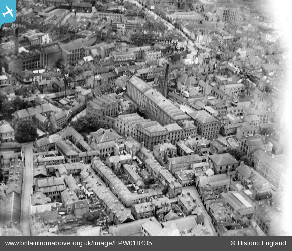
EPW018435 ENGLAND (1927). Bond Street Mills and environs, Leicester, 1927
© Copyright OpenStreetMap contributors and licensed by the OpenStreetMap Foundation. 2026. Cartography is licensed as CC BY-SA.
Nearby Images (10)
Details
| Title | [EPW018435] Bond Street Mills and environs, Leicester, 1927 |
| Reference | EPW018435 |
| Date | 10-June-1927 |
| Link | |
| Place name | LEICESTER |
| Parish | |
| District | |
| Country | ENGLAND |
| Easting / Northing | 458587, 304694 |
| Longitude / Latitude | -1.1341671695386, 52.636476700349 |
| National Grid Reference | SK586047 |
Pins

Class31 |
Sunday 10th of February 2013 04:26:19 PM | |

Class31 |
Sunday 10th of February 2013 04:22:21 PM | |

Class31 |
Sunday 10th of February 2013 04:21:13 PM | |

Class31 |
Sunday 10th of February 2013 04:20:29 PM | |

Class31 |
Sunday 10th of February 2013 04:18:51 PM | |

Class31 |
Sunday 10th of February 2013 04:16:59 PM | |

Class31 |
Sunday 10th of February 2013 04:16:05 PM | |

Class31 |
Sunday 10th of February 2013 04:15:22 PM | |

Underwood55 |
Tuesday 11th of December 2012 08:35:26 PM |
User Comment Contributions
View looking east. |

Class31 |
Sunday 10th of February 2013 04:23:11 PM |


![[EPW018435] Bond Street Mills and environs, Leicester, 1927](http://britainfromabove.org.uk/sites/all/libraries/aerofilms-images/public/100x100/EPW/018/EPW018435.jpg)
![[EPW020895] The city centre, Leicester, 1928](http://britainfromabove.org.uk/sites/all/libraries/aerofilms-images/public/100x100/EPW/020/EPW020895.jpg)
![[EPW055006] The Haymarket and the city centre, Leicester, 1937](http://britainfromabove.org.uk/sites/all/libraries/aerofilms-images/public/100x100/EPW/055/EPW055006.jpg)
![[EPW047641] The Haymarket and city centre, Leicester, 1935](http://britainfromabove.org.uk/sites/all/libraries/aerofilms-images/public/100x100/EPW/047/EPW047641.jpg)
![[EPW047645] The city centre, Leicester, 1935](http://britainfromabove.org.uk/sites/all/libraries/aerofilms-images/public/100x100/EPW/047/EPW047645.jpg)
![[EPW018433] East Gates and environs, Leicester, 1927](http://britainfromabove.org.uk/sites/all/libraries/aerofilms-images/public/100x100/EPW/018/EPW018433.jpg)
![[EPW047643] The Clock Tower and the city centre, Leicester, 1935](http://britainfromabove.org.uk/sites/all/libraries/aerofilms-images/public/100x100/EPW/047/EPW047643.jpg)
![[EAW024243] The Clock Tower, Humberstone Gate and the city centre, Leicester, 1949](http://britainfromabove.org.uk/sites/all/libraries/aerofilms-images/public/100x100/EAW/024/EAW024243.jpg)
![[EAW024242] Gallowtree Gate, Cheapside and the city centre, Leicester, 1949](http://britainfromabove.org.uk/sites/all/libraries/aerofilms-images/public/100x100/EAW/024/EAW024242.jpg)
![[EAW051834] The city centre around High Street and Humberstone Gate, Leicester, 1953](http://britainfromabove.org.uk/sites/all/libraries/aerofilms-images/public/100x100/EAW/051/EAW051834.jpg)