
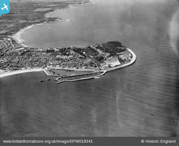
EPW018341 ENGLAND (1927). Castle Hill and the harbour, Scarborough, 1927. This image has been produced from a copy-negative.
© Copyright OpenStreetMap contributors and licensed by the OpenStreetMap Foundation. 2026. Cartography is licensed as CC BY-SA.
Nearby Images (7)
EPW018341

EPW038935

EPW029089

EAW016698

EAW016694

EAW016690

EAW016688

Details
| Title | [EPW018341] Castle Hill and the harbour, Scarborough, 1927. This image has been produced from a copy-negative. |
| Reference | EPW018341 |
| Date | 10-June-1927 |
| Link | |
| Place name | SCARBOROUGH |
| Parish | |
| District | |
| Country | ENGLAND |
| Easting / Northing | 505038, 488820 |
| Longitude / Latitude | -0.38635124494938, 54.284047655199 |
| National Grid Reference | TA050888 |
Pins

John Wass |
Saturday 1st of November 2014 07:49:03 PM |
User Comment Contributions
Scarborough |

Alan McFaden |
Tuesday 18th of November 2014 03:30:19 PM |

Scarborough Fishermen's Dock |
Alan McFaden |
Tuesday 18th of November 2014 03:29:43 PM |

Scarborough Harbour |
Alan McFaden |
Tuesday 18th of November 2014 03:29:12 PM |

Scarborough Beach and Castle |
Alan McFaden |
Tuesday 18th of November 2014 03:28:40 PM |

Scarborough Bay |
Alan McFaden |
Tuesday 18th of November 2014 03:27:56 PM |