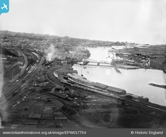
EPW017754 ENGLAND (1927). Swing bridge over the River Arun and environs, Littlehampton, from the north-west, 1927
    © Copyright OpenStreetMap contributors and licensed by the OpenStreetMap Foundation. 2025. Cartography is licensed as CC BY-SA.
  
Nearby Images (5)
Details
| Title | [EPW017754] Swing bridge over the River Arun and environs, Littlehampton, from the north-west, 1927 | 
| Reference | EPW017754 | 
| Date | May-1927 | 
| Link | |
| Place name | LITTLEHAMPTON | 
| Parish | LITTLEHAMPTON | 
| District | |
| Country | ENGLAND | 
| Easting / Northing | 502105, 102327 | 
| Longitude / Latitude | -0.55059499171993, 50.810921264971 | 
| National Grid Reference | TQ021023 | 
Pins
Be the first to add a comment to this image!
 
             
  ![[EPW017754] Swing bridge over the River Arun and environs, Littlehampton, from the north-west, 1927](http://britainfromabove.org.uk/sites/all/libraries/aerofilms-images/public/100x100/EPW/017/EPW017754.jpg) 
  
                                          ![[EPW017753] Swing bridge over the River Arun and environs, Littlehampton, from the south-west, 1927.  Double-exposed negative.](http://britainfromabove.org.uk/sites/all/libraries/aerofilms-images/public/100x100/EPW/017/EPW017753.jpg) 
 ![[EPW000681] The River Arun, Littlehampton, from the north-west, 1920](http://britainfromabove.org.uk/sites/all/libraries/aerofilms-images/public/100x100/EPW/000/EPW000681.jpg) 
 ![[EAW012232] The River Arun and the town, Littlehampton, from the south-west, 1947](http://britainfromabove.org.uk/sites/all/libraries/aerofilms-images/public/100x100/EAW/012/EAW012232.jpg) 
 ![[EPW039463] The town alongside the River Arun, Littlehampton, 1932](http://britainfromabove.org.uk/sites/all/libraries/aerofilms-images/public/100x100/EPW/039/EPW039463.jpg)