
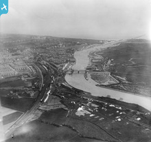
EPW000681 ENGLAND (1920). The River Arun, Littlehampton, from the north-west, 1920

© Copyright OpenStreetMap contributors and licensed by the OpenStreetMap Foundation. 2026. Cartography is licensed as CC BY-SA.
Nearby Images (2)
EPW000681

EPW017754

Details
| Title | [EPW000681] The River Arun, Littlehampton, from the north-west, 1920 |
| Reference | EPW000681 |
| Date | April-1920 |
| Link | |
| Place name | LITTLEHAMPTON |
| Parish | LITTLEHAMPTON |
| District | |
| Country | ENGLAND |
| Easting / Northing | 501930, 102440 |
| Longitude / Latitude | -0.55304691871178, 50.811968042573 |
| National Grid Reference | TQ019024 |
Pins

JonathanWebb |
Sunday 29th of September 2019 07:13:30 AM |
User Comment Contributions
Littlehampton station, goods yard and surrounding area |
tomoliver |
Monday 2nd of July 2012 08:31:42 PM |