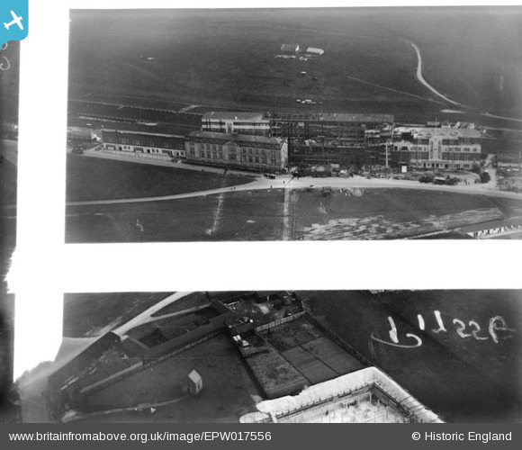
EPW017556 ENGLAND (1927). The Epsom racecourse grandstand under construction, Epsom Downs, 1927. This image was marked by Aerofilms Ltd for photo editing.
© Copyright OpenStreetMap contributors and licensed by the OpenStreetMap Foundation. 2026. Cartography is licensed as CC BY-SA.
Nearby Images (36)
Details
| Title | [EPW017556] The Epsom racecourse grandstand under construction, Epsom Downs, 1927. This image was marked by Aerofilms Ltd for photo editing. |
| Reference | EPW017556 |
| Date | April-1927 |
| Link | |
| Place name | EPSOM DOWNS |
| Parish | |
| District | |
| Country | ENGLAND |
| Easting / Northing | 521773, 158650 |
| Longitude / Latitude | -0.25256652034636, 51.313409681683 |
| National Grid Reference | TQ218587 |
Pins
Be the first to add a comment to this image!


![[EPW017556] The Epsom racecourse grandstand under construction, Epsom Downs, 1927. This image was marked by Aerofilms Ltd for photo editing.](http://britainfromabove.org.uk/sites/all/libraries/aerofilms-images/public/100x100/EPW/017/EPW017556.jpg)
![[EPW006394] Epsom Downs, Derby Day car parking at Epsom Racecourse, 1921. This image has been produced from a print.](http://britainfromabove.org.uk/sites/all/libraries/aerofilms-images/public/100x100/EPW/006/EPW006394.jpg)
![[EPW008665] The Grandstand, Epsom, 1923](http://britainfromabove.org.uk/sites/all/libraries/aerofilms-images/public/100x100/EPW/008/EPW008665.jpg)
![[EPW007651] The Grandstand at Epsom Racecourse, Epsom, 1922](http://britainfromabove.org.uk/sites/all/libraries/aerofilms-images/public/100x100/EPW/007/EPW007651.jpg)
![[EPW027522] Epsom Downs, Derby Day, 1929](http://britainfromabove.org.uk/sites/all/libraries/aerofilms-images/public/100x100/EPW/027/EPW027522.jpg)
![[EPW006485] Parking between the Derby Arms pub and the Grand Stand at Epsom Racecourse on Derby Day, Epsom Downs, 1921](http://britainfromabove.org.uk/sites/all/libraries/aerofilms-images/public/100x100/EPW/006/EPW006485.jpg)
![[EPW006482] Epsom Racecourse on Derby Day, Epsom Downs, 1921](http://britainfromabove.org.uk/sites/all/libraries/aerofilms-images/public/100x100/EPW/006/EPW006482.jpg)
![[EPW017555] The Epsom racecourse grandstand under construction, Epsom Downs, 1927. This image was marked by Aerofilms Ltd for photo editing.](http://britainfromabove.org.uk/sites/all/libraries/aerofilms-images/public/100x100/EPW/017/EPW017555.jpg)
![[EAW000990] Epsom Downs, crowds at the Epsom Race Course Victory Derby, from the south, 1946. This image has been produced from a damaged negative.](http://britainfromabove.org.uk/sites/all/libraries/aerofilms-images/public/100x100/EAW/000/EAW000990.jpg)
![[EPW025150] The Epsom Downs Race Course Grand Stand and Prince's Stand, Epsom Downs, 1928](http://britainfromabove.org.uk/sites/all/libraries/aerofilms-images/public/100x100/EPW/025/EPW025150.jpg)
![[EPW007650] The Grandstand at Epsom Racecourse, Epsom, 1922](http://britainfromabove.org.uk/sites/all/libraries/aerofilms-images/public/100x100/EPW/007/EPW007650.jpg)
![[EPW007902] The grandstand at Epsom Racecourse, Epsom Downs, 1922](http://britainfromabove.org.uk/sites/all/libraries/aerofilms-images/public/100x100/EPW/007/EPW007902.jpg)
![[EPW006444] Parking between the Derby Arms and the Grandstand at Epsom Racecourse on Derby Day, Epsom Downs, 1921](http://britainfromabove.org.uk/sites/all/libraries/aerofilms-images/public/100x100/EPW/006/EPW006444.jpg)
![[EPW025156] Epsom Downs Race Course and Grand Stand, Epsom Downs, 1928](http://britainfromabove.org.uk/sites/all/libraries/aerofilms-images/public/100x100/EPW/025/EPW025156.jpg)
![[EPW025157] Epsom Downs Race Course and Grand Stand, Epsom Downs, 1928](http://britainfromabove.org.uk/sites/all/libraries/aerofilms-images/public/100x100/EPW/025/EPW025157.jpg)
![[EPW008703] The Grandstand and Home Straight, Epsom, 1923](http://britainfromabove.org.uk/sites/all/libraries/aerofilms-images/public/100x100/EPW/008/EPW008703.jpg)
![[EPW007652] The Grandstand at Epsom Racecourse, Epsom, 1922](http://britainfromabove.org.uk/sites/all/libraries/aerofilms-images/public/100x100/EPW/007/EPW007652.jpg)
![[EPW027456] Epsom Downs, Derby Day, 1929](http://britainfromabove.org.uk/sites/all/libraries/aerofilms-images/public/100x100/EPW/027/EPW027456.jpg)
![[EPW006484] Epsom Racecourse on Derby Day, Epsom Downs, from the north-west, 1921](http://britainfromabove.org.uk/sites/all/libraries/aerofilms-images/public/100x100/EPW/006/EPW006484.jpg)
![[EAW036444] Epsom Downs, Epsom Racecourse on Derby Day, 1951. This image has been produced from a print.](http://britainfromabove.org.uk/sites/all/libraries/aerofilms-images/public/100x100/EAW/036/EAW036444.jpg)
![[EPW025158] Epsom Downs Race Course and Grand Stand, Epsom Downs, from the south-east, 1928](http://britainfromabove.org.uk/sites/all/libraries/aerofilms-images/public/100x100/EPW/025/EPW025158.jpg)
![[EPW025144] The Epsom Downs Race Course Grand Stand, Epsom Downs, from the south-east, 1928](http://britainfromabove.org.uk/sites/all/libraries/aerofilms-images/public/100x100/EPW/025/EPW025144.jpg)
![[EAW017624] The Grandstand at Epsom Racecourse, Epsom Downs, from the south, 1948. This image has been produced from a print.](http://britainfromabove.org.uk/sites/all/libraries/aerofilms-images/public/100x100/EAW/017/EAW017624.jpg)
![[EPW006431] Epsom Downs, Derby Day crowds at Epsom Racecourse, 1921. This image has been produced from a print.](http://britainfromabove.org.uk/sites/all/libraries/aerofilms-images/public/100x100/EPW/006/EPW006431.jpg)
![[EPW017557] The Epsom racecourse grandstand under construction, Epsom Downs, 1927. This image was marked by Aerofilms Ltd for photo editing.](http://britainfromabove.org.uk/sites/all/libraries/aerofilms-images/public/100x100/EPW/017/EPW017557.jpg)
![[EPW035522] The Grandstand and racecouse on Derby Day, Epsom Downs, from the north-west, 1931. This image has been produced from a damaged negative.](http://britainfromabove.org.uk/sites/all/libraries/aerofilms-images/public/100x100/EPW/035/EPW035522.jpg)
![[EPW008671] The Winning Post, Epsom, 1923](http://britainfromabove.org.uk/sites/all/libraries/aerofilms-images/public/100x100/EPW/008/EPW008671.jpg)
![[EPW006380] Epsom Racecourse, Epsom Downs, 1921](http://britainfromabove.org.uk/sites/all/libraries/aerofilms-images/public/100x100/EPW/006/EPW006380.jpg)
![[EPW007901] Epsom Racecourse, Epsom Downs, from the west, 1922](http://britainfromabove.org.uk/sites/all/libraries/aerofilms-images/public/100x100/EPW/007/EPW007901.jpg)
![[EPW035515] Epsom Downs, Derby Day, 1931](http://britainfromabove.org.uk/sites/all/libraries/aerofilms-images/public/100x100/EPW/035/EPW035515.jpg)
![[EPW008663] Temporary booths for race day, Epsom, 1923](http://britainfromabove.org.uk/sites/all/libraries/aerofilms-images/public/100x100/EPW/008/EPW008663.jpg)
![[EPW007653] The Home Straight at Epsom Racecourse, Epsom, from the east, 1922](http://britainfromabove.org.uk/sites/all/libraries/aerofilms-images/public/100x100/EPW/007/EPW007653.jpg)
![[EPW027457] Epsom Downs, Derby Day, 1929](http://britainfromabove.org.uk/sites/all/libraries/aerofilms-images/public/100x100/EPW/027/EPW027457.jpg)
![[EAW000991] Epsom Downs, crowds at the Epsom Race Course Victory Derby, from the south, 1946. This image has been produced from a damaged negative.](http://britainfromabove.org.uk/sites/all/libraries/aerofilms-images/public/100x100/EAW/000/EAW000991.jpg)
![[EPW027458] Epsom Downs, Derby Day, 1929](http://britainfromabove.org.uk/sites/all/libraries/aerofilms-images/public/100x100/EPW/027/EPW027458.jpg)
![[EPW035511] The Grandstand and racecourse on Derby Day, Epsom Downs, from the north, 1931](http://britainfromabove.org.uk/sites/all/libraries/aerofilms-images/public/100x100/EPW/035/EPW035511.jpg)