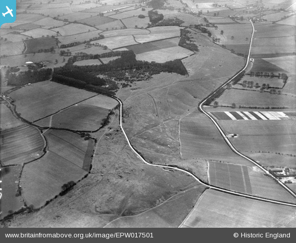
EPW017501 ENGLAND (1927). The Whipsnade Estate, Whipsnade, 1927
© Copyright OpenStreetMap contributors and licensed by the OpenStreetMap Foundation. 2026. Cartography is licensed as CC BY-SA.
Nearby Images (9)
Details
| Title | [EPW017501] The Whipsnade Estate, Whipsnade, 1927 |
| Reference | EPW017501 |
| Date | March-1927 |
| Link | |
| Place name | WHIPSNADE |
| Parish | WHIPSNADE |
| District | |
| Country | ENGLAND |
| Easting / Northing | 499895, 218168 |
| Longitude / Latitude | -0.54945605694915, 51.852711038418 |
| National Grid Reference | SP999182 |
Pins

Bluid |
Thursday 29th of May 2014 07:45:51 AM |


![[EPW017501] The Whipsnade Estate, Whipsnade, 1927](http://britainfromabove.org.uk/sites/all/libraries/aerofilms-images/public/100x100/EPW/017/EPW017501.jpg)
![[EPW035110] Whipsnade Park Zoo and surrounding countryside, Whipsnade, 1931](http://britainfromabove.org.uk/sites/all/libraries/aerofilms-images/public/100x100/EPW/035/EPW035110.jpg)
![[EPW017499] The Whipsnade Estate, Whipsnade, from the north-west, 1927](http://britainfromabove.org.uk/sites/all/libraries/aerofilms-images/public/100x100/EPW/017/EPW017499.jpg)
![[EPW017500] The Whipsnade Estate, Whipsnade, from the north-west, 1927](http://britainfromabove.org.uk/sites/all/libraries/aerofilms-images/public/100x100/EPW/017/EPW017500.jpg)
![[EPW017504] The Whipsnade Estate, Whipsnade, from the north-west, 1927](http://britainfromabove.org.uk/sites/all/libraries/aerofilms-images/public/100x100/EPW/017/EPW017504.jpg)
![[EPW035111] Whipsnade Park Zoo and surrounding countryside, Whipsnade, from the north-west, 1931](http://britainfromabove.org.uk/sites/all/libraries/aerofilms-images/public/100x100/EPW/035/EPW035111.jpg)
![[EPW017515] The Whipsnade Estate, Whipsnade, from the west, 1927](http://britainfromabove.org.uk/sites/all/libraries/aerofilms-images/public/100x100/EPW/017/EPW017515.jpg)
![[EPW017517] The Whipsnade Estate, Whipsnade, from north-west, 1927](http://britainfromabove.org.uk/sites/all/libraries/aerofilms-images/public/100x100/EPW/017/EPW017517.jpg)
![[EPW017513] The Whipsnade Estate, Whipsnade, from the north-west, 1927](http://britainfromabove.org.uk/sites/all/libraries/aerofilms-images/public/100x100/EPW/017/EPW017513.jpg)