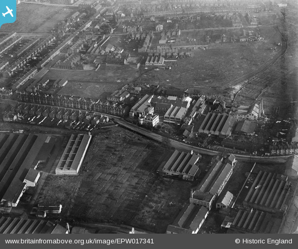
EPW017341 ENGLAND (1926). Baird & Tatlock's Scientific Instrument Factory and environs, Walthamstow, 1926
© Copyright OpenStreetMap contributors and licensed by the OpenStreetMap Foundation. 2026. Cartography is licensed as CC BY-SA.
Nearby Images (38)
Details
| Title | [EPW017341] Baird & Tatlock's Scientific Instrument Factory and environs, Walthamstow, 1926 |
| Reference | EPW017341 |
| Date | 8-December-1926 |
| Link | |
| Place name | WALTHAMSTOW |
| Parish | |
| District | |
| Country | ENGLAND |
| Easting / Northing | 535885, 189859 |
| Longitude / Latitude | -0.038190818414434, 51.590700036609 |
| National Grid Reference | TQ359899 |
Pins

Dank |
Friday 8th of May 2020 07:28:57 PM |
User Comment Contributions
Based on Image 017340 a good reference point is the track which appears just behind the factory and runs to the right and upwards. This is the outline of Sutherland Road which joins St Andrews Road (left) and exits near Higham Street (top right). Based on Image 017341 just towards the top Left corner (along St Andrews Road) on the righthand side of that is Higham Hill Primary School. You can just pick out (zooming in) the gate pillars, the main school building, the playground and rain canopy - typical of early 1900's Board Schools and a further school building to the right all enclosed by usual 5 foot brick walling. The factory sheds that appear in the bottom right corner belong to the Micanite & Insulator's works(Hooker Road). Here they made and perfected 'Tego' Gluefilm, a top secret preparation that coated the fuselage of some of Britain's WW2 fighter planes. There used to be the works nameplate painted black on yellow (8 foot x 2 foot)on the flank wall of Hooker Road off Blackhorse Lane, but somebody pinched that around about 1992. |
 8-2007.JPG)
Keith |
Saturday 30th of June 2012 10:56:42 AM |


![[EPW017341] Baird & Tatlock's Scientific Instrument Factory and environs, Walthamstow, 1926](http://britainfromabove.org.uk/sites/all/libraries/aerofilms-images/public/100x100/EPW/017/EPW017341.jpg)
![[EPW017339] Works and industry off Blackhorse Lane and environs, Walthamstow, 1926](http://britainfromabove.org.uk/sites/all/libraries/aerofilms-images/public/100x100/EPW/017/EPW017339.jpg)
![[EPW017337] Baird & Tatlock's Scientific Instrument Factory, Walthamstow, 1926](http://britainfromabove.org.uk/sites/all/libraries/aerofilms-images/public/100x100/EPW/017/EPW017337.jpg)
![[EPW017338] Baird & Tatlock's Scientific Instrument Factory and environs, Walthamstow, 1926](http://britainfromabove.org.uk/sites/all/libraries/aerofilms-images/public/100x100/EPW/017/EPW017338.jpg)
![[EPW017340] Baird & Tatlock's Scientific Instrument Factory, Walthamstow, 1926](http://britainfromabove.org.uk/sites/all/libraries/aerofilms-images/public/100x100/EPW/017/EPW017340.jpg)
![[EPW017344] Baird & Tatlock's Scientific Instrument Factory and environs, Walthamstow, 1926](http://britainfromabove.org.uk/sites/all/libraries/aerofilms-images/public/100x100/EPW/017/EPW017344.jpg)
![[EPW037541] The Micanite and Insulators Co Ltd Empire Works and other factories, Walthamstow, 1932](http://britainfromabove.org.uk/sites/all/libraries/aerofilms-images/public/100x100/EPW/037/EPW037541.jpg)
![[EAW025748] Works off Blackhorse Lane, Walthamstow, 1949. This image has been produced from a print marked by Aerofilms Ltd for photo editing.](http://britainfromabove.org.uk/sites/all/libraries/aerofilms-images/public/100x100/EAW/025/EAW025748.jpg)
![[EPW037544] The Micanite and Insulators Co Ltd Empire Works and other factories, Walthamstow, 1932](http://britainfromabove.org.uk/sites/all/libraries/aerofilms-images/public/100x100/EPW/037/EPW037544.jpg)
![[EPW037545] The Micanite and Insulators Co Ltd Empire Works and other factories, Walthamstow, 1932](http://britainfromabove.org.uk/sites/all/libraries/aerofilms-images/public/100x100/EPW/037/EPW037545.jpg)
![[EPW037543] The Micanite and Insulators Co Ltd Empire Works and other factories, Walthamstow, 1932](http://britainfromabove.org.uk/sites/all/libraries/aerofilms-images/public/100x100/EPW/037/EPW037543.jpg)
![[EPW037919] Factories next to the High Maynard Reservoir, Higham Hill, 1932](http://britainfromabove.org.uk/sites/all/libraries/aerofilms-images/public/100x100/EPW/037/EPW037919.jpg)
![[EPW037546] The Micanite and Insulators Co Ltd Empire Works and other factories, Walthamstow, 1932](http://britainfromabove.org.uk/sites/all/libraries/aerofilms-images/public/100x100/EPW/037/EPW037546.jpg)
![[EPW037540] The Micanite and Insulators Co Ltd Empire Works, Walthamstow, 1932](http://britainfromabove.org.uk/sites/all/libraries/aerofilms-images/public/100x100/EPW/037/EPW037540.jpg)
![[EPW037922] Factories next to the High Maynard Reservoir, Higham Hill, 1932](http://britainfromabove.org.uk/sites/all/libraries/aerofilms-images/public/100x100/EPW/037/EPW037922.jpg)
![[EPW037547] The Micanite and Insulators Co Ltd Empire Works, Walthamstow, 1932](http://britainfromabove.org.uk/sites/all/libraries/aerofilms-images/public/100x100/EPW/037/EPW037547.jpg)
![[EPW037921] Factories next to the High Maynard Reservoir, Higham Hill, 1932](http://britainfromabove.org.uk/sites/all/libraries/aerofilms-images/public/100x100/EPW/037/EPW037921.jpg)
![[EPW037918] Factories next to the High Maynard Reservoir, Higham Hill, 1932](http://britainfromabove.org.uk/sites/all/libraries/aerofilms-images/public/100x100/EPW/037/EPW037918.jpg)
![[EPW037920] Factories next to the High Maynard Reservoir, Higham Hill, 1932](http://britainfromabove.org.uk/sites/all/libraries/aerofilms-images/public/100x100/EPW/037/EPW037920.jpg)
![[EPW037542] The Micanite and Insulators Co Ltd Empire Works, Walthamstow, 1932](http://britainfromabove.org.uk/sites/all/libraries/aerofilms-images/public/100x100/EPW/037/EPW037542.jpg)
![[EAW035357] Higham Hill Primary Junior Mixed School and St Andrew Mills Ltd Paper Mills off St Andrew Road, Higham Hill, 1951. This image has been produced from a print marked by Aerofilms Ltd for photo editing.](http://britainfromabove.org.uk/sites/all/libraries/aerofilms-images/public/100x100/EAW/035/EAW035357.jpg)
![[EAW025752] Works off Blackhorse Lane, Walthamstow, 1949. This image has been produced from a print marked by Aerofilms Ltd for photo editing.](http://britainfromabove.org.uk/sites/all/libraries/aerofilms-images/public/100x100/EAW/025/EAW025752.jpg)
![[EAW025746] Works off Blackhorse Lane, Walthamstow, 1949. This image has been produced from a print marked by Aerofilms Ltd for photo editing.](http://britainfromabove.org.uk/sites/all/libraries/aerofilms-images/public/100x100/EAW/025/EAW025746.jpg)
![[EAW035350] St Andrew Mills Ltd Paper Mills off St Andrew Road and environs, Higham Hill, 1951. This image has been produced from a print marked by Aerofilms Ltd for photo editing.](http://britainfromabove.org.uk/sites/all/libraries/aerofilms-images/public/100x100/EAW/035/EAW035350.jpg)
![[EAW035351] St Andrew Mills Ltd Paper Mills and Higham Street, Higham Hill, 1951. This image has been produced from a print marked by Aerofilms Ltd for photo editing.](http://britainfromabove.org.uk/sites/all/libraries/aerofilms-images/public/100x100/EAW/035/EAW035351.jpg)
![[EAW035349] St Andrew Mills Ltd Paper Mills off St Andrew Road, Higham Hill, 1951. This image has been produced from a print marked by Aerofilms Ltd for photo editing.](http://britainfromabove.org.uk/sites/all/libraries/aerofilms-images/public/100x100/EAW/035/EAW035349.jpg)
![[EAW025753] Works off Blackhorse Lane, Walthamstow, 1949. This image has been produced from a print.](http://britainfromabove.org.uk/sites/all/libraries/aerofilms-images/public/100x100/EAW/025/EAW025753.jpg)
![[EPW037925] Factories next to the High Maynard Reservoir, Higham Hill, 1932](http://britainfromabove.org.uk/sites/all/libraries/aerofilms-images/public/100x100/EPW/037/EPW037925.jpg)
![[EAW035353] St Andrew Mills Ltd Paper Mills and Higham Street, Higham Hill, 1951. This image has been produced from a print marked by Aerofilms Ltd for photo editing.](http://britainfromabove.org.uk/sites/all/libraries/aerofilms-images/public/100x100/EAW/035/EAW035353.jpg)
![[EAW025749] Works off Blackhorse Lane, Walthamstow, 1949. This image has been produced from a print marked by Aerofilms Ltd for photo editing.](http://britainfromabove.org.uk/sites/all/libraries/aerofilms-images/public/100x100/EAW/025/EAW025749.jpg)
![[EAW035352] St Andrew Mills Ltd Paper Mills and Higham Street, Higham Hill, 1951. This image has been produced from a print marked by Aerofilms Ltd for photo editing.](http://britainfromabove.org.uk/sites/all/libraries/aerofilms-images/public/100x100/EAW/035/EAW035352.jpg)
![[EPW037926] Factories next to the High Maynard Reservoir, Higham Hill, 1932](http://britainfromabove.org.uk/sites/all/libraries/aerofilms-images/public/100x100/EPW/037/EPW037926.jpg)
![[EAW035359] St Andrew Mills Ltd Paper Mills, Higham Hill, 1951. This image has been produced from a print marked by Aerofilms Ltd for photo editing.](http://britainfromabove.org.uk/sites/all/libraries/aerofilms-images/public/100x100/EAW/035/EAW035359.jpg)
![[EAW025751] Works off Blackhorse Lane, Walthamstow, 1949. This image has been produced from a print.](http://britainfromabove.org.uk/sites/all/libraries/aerofilms-images/public/100x100/EAW/025/EAW025751.jpg)
![[EPW037923] Factories next to the High Maynard Reservoir, Higham Hill, 1932](http://britainfromabove.org.uk/sites/all/libraries/aerofilms-images/public/100x100/EPW/037/EPW037923.jpg)
![[EAW025747] Works off Blackhorse Lane and the High and Low Maynard Reservoirs, Walthamstow, 1949. This image has been produced from a print marked by Aerofilms Ltd for photo editing.](http://britainfromabove.org.uk/sites/all/libraries/aerofilms-images/public/100x100/EAW/025/EAW025747.jpg)
![[EAW035358] St Andrew Mills Ltd Paper Mills, Higham Hill, 1951. This image has been produced from a print marked by Aerofilms Ltd for photo editing.](http://britainfromabove.org.uk/sites/all/libraries/aerofilms-images/public/100x100/EAW/035/EAW035358.jpg)
![[EPW037927] Factories next to the High Maynard Reservoir, Higham Hill, 1932](http://britainfromabove.org.uk/sites/all/libraries/aerofilms-images/public/100x100/EPW/037/EPW037927.jpg)