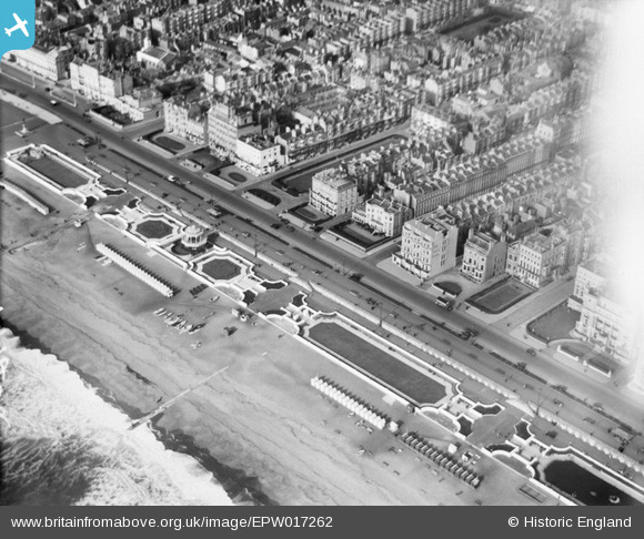
EPW017262 ENGLAND (1926). King's Road and the Western Bandstand, Brighton, 1926
© Copyright OpenStreetMap contributors and licensed by the OpenStreetMap Foundation. 2026. Cartography is licensed as CC BY-SA.
Nearby Images (16)
Details
| Title | [EPW017262] King's Road and the Western Bandstand, Brighton, 1926 |
| Reference | EPW017262 |
| Date | October-1926 |
| Link | |
| Place name | BRIGHTON |
| Parish | |
| District | |
| Country | ENGLAND |
| Easting / Northing | 530110, 104148 |
| Longitude / Latitude | -0.15260825066357, 50.821675861479 |
| National Grid Reference | TQ301041 |
Pins

Alan McFaden |
Tuesday 2nd of April 2013 10:35:10 AM | |

Alan McFaden |
Monday 25th of March 2013 10:53:00 AM | |

Alan McFaden |
Monday 25th of March 2013 10:51:53 AM | |

Alan McFaden |
Monday 25th of March 2013 10:51:11 AM | |

MB |
Friday 5th of October 2012 02:48:31 PM | |

MB |
Friday 5th of October 2012 02:47:16 PM | |

MB |
Friday 5th of October 2012 02:46:19 PM | |

classicforever |
Thursday 28th of June 2012 08:38:24 PM | |

classicforever |
Thursday 28th of June 2012 08:37:38 PM | |
This is Abinger House, owned by Lady Abinger, later bought by the local MP. The building was commandeered by the forces in WW2 then it laid empty for several years. It was demolished in the late 1950's and replaced with a bar/restaurant built by Edlins, renamed the Abinger the new structure only lasted until the mid 1980's before being demolished to make way for a 6 story apartment block which still stands today. |

Dr Jetty |
Monday 26th of October 2015 11:16:35 AM |
User Comment Contributions

classicforever |
Thursday 28th of June 2012 08:39:30 PM |


![[EPW017262] King's Road and the Western Bandstand, Brighton, 1926](http://britainfromabove.org.uk/sites/all/libraries/aerofilms-images/public/100x100/EPW/017/EPW017262.jpg)
![[EPW054141] King's Road and the Esplanade Band Stand and Putting Green, Brighton, 1937](http://britainfromabove.org.uk/sites/all/libraries/aerofilms-images/public/100x100/EPW/054/EPW054141.jpg)
![[EPW039539] Kings Road, the West Pier Concert Hall and the town by the seafront, Brighton, 1932](http://britainfromabove.org.uk/sites/all/libraries/aerofilms-images/public/100x100/EPW/039/EPW039539.jpg)
![[EAW022259] The seafront alongside King's Road and the town, Brighton, from the south-west, 1949](http://britainfromabove.org.uk/sites/all/libraries/aerofilms-images/public/100x100/EAW/022/EAW022259.jpg)
![[EPW045507] The seafront and town, Brighton, from the south-west, 1934. This image has been produced from a copy-negative.](http://britainfromabove.org.uk/sites/all/libraries/aerofilms-images/public/100x100/EPW/045/EPW045507.jpg)
![[EPW054034] Embassy Court and the town, Brighton, from the south-east, 1937](http://britainfromabove.org.uk/sites/all/libraries/aerofilms-images/public/100x100/EPW/054/EPW054034.jpg)
![[EPW035292] The Esplanade and the beach, Brighton, from the west, 1931. This image has been produced from a copy-negative.](http://britainfromabove.org.uk/sites/all/libraries/aerofilms-images/public/100x100/EPW/035/EPW035292.jpg)
![[EAW022684] West Pier, Regency Square and the town between Brunswick Square and St Ann's Well Gardens, Brighton, 1949](http://britainfromabove.org.uk/sites/all/libraries/aerofilms-images/public/100x100/EAW/022/EAW022684.jpg)
![[EAW011027] The seafront and the town, Brighton, 1947](http://britainfromabove.org.uk/sites/all/libraries/aerofilms-images/public/100x100/EAW/011/EAW011027.jpg)
![[EPW011505] Regency Square, King's Road and the seafront, Brighton, 1924. This image has been produced from a copy-negative.](http://britainfromabove.org.uk/sites/all/libraries/aerofilms-images/public/100x100/EPW/011/EPW011505.jpg)
![[EAW011026] West Pier and the town, Brighton, 1947](http://britainfromabove.org.uk/sites/all/libraries/aerofilms-images/public/100x100/EAW/011/EAW011026.jpg)
![[EPW041375] Regency Square, Brighton, 1933](http://britainfromabove.org.uk/sites/all/libraries/aerofilms-images/public/100x100/EPW/041/EPW041375.jpg)
![[EAW022680] West Pier and Regency Square, Brighton, 1949](http://britainfromabove.org.uk/sites/all/libraries/aerofilms-images/public/100x100/EAW/022/EAW022680.jpg)
![[EPW039535] The town centre and the seafront, Brighton, 1932](http://britainfromabove.org.uk/sites/all/libraries/aerofilms-images/public/100x100/EPW/039/EPW039535.jpg)
![[EPW018067] Waterloo Street and the seafront, Brighton, from the south, 1927](http://britainfromabove.org.uk/sites/all/libraries/aerofilms-images/public/100x100/EPW/018/EPW018067.jpg)
![[EAW043167] The West Pier, Brighton, 1952](http://britainfromabove.org.uk/sites/all/libraries/aerofilms-images/public/100x100/EAW/043/EAW043167.jpg)


