
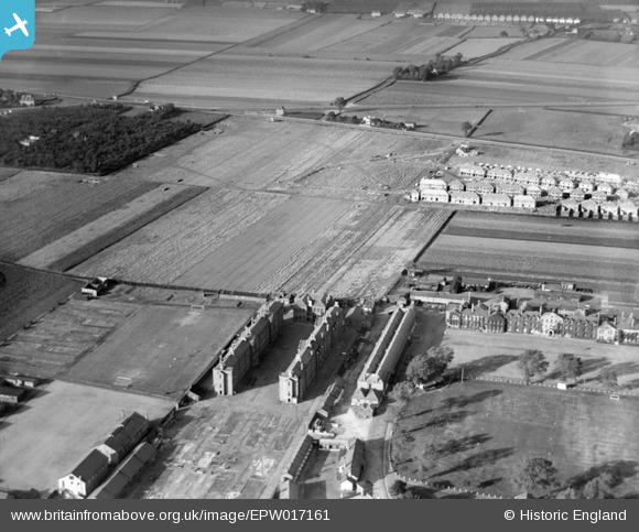
EPW017161 ENGLAND (1926). The Hounslow Barracks and new housing at Francis Road, Hounslow, 1926
© Copyright OpenStreetMap contributors and licensed by the OpenStreetMap Foundation. 2026. Cartography is licensed as CC BY-SA.
Nearby Images (4)
EPW017161

EPW023228

EPW023237

EPW017162

Details
| Title | [EPW017161] The Hounslow Barracks and new housing at Francis Road, Hounslow, 1926 |
| Reference | EPW017161 |
| Date | October-1926 |
| Link | |
| Place name | HOUNSLOW |
| Parish | |
| District | |
| Country | ENGLAND |
| Easting / Northing | 511804, 175845 |
| Longitude / Latitude | -0.39014100608806, 51.470024427795 |
| National Grid Reference | TQ118758 |
Pins

Martin Devlin |
Saturday 20th of March 2021 10:56:11 AM | |
|
Isleworth1961 |
Friday 16th of February 2018 12:25:36 AM | |
|
PhilD |
Tuesday 2nd of August 2016 11:38:57 PM | |
|
MB |
Wednesday 3rd of October 2012 10:50:35 PM | |
|
MB |
Wednesday 3rd of October 2012 10:50:04 PM | |
Travellers Friend |
PhilD |
Tuesday 2nd of August 2016 11:36:41 PM |
|
MB |
Wednesday 3rd of October 2012 10:44:27 PM | |
This was originally named 'Hounslow Barracks Station' |
MB |
Wednesday 3rd of October 2012 10:49:02 PM |
|
MB |
Wednesday 3rd of October 2012 10:42:04 PM | |
|
MB |
Wednesday 3rd of October 2012 10:41:36 PM | |
|
MB |
Wednesday 3rd of October 2012 10:41:07 PM | |
A new road, built since 1920 |
MB |
Wednesday 3rd of October 2012 10:45:09 PM |
|
MB |
Wednesday 3rd of October 2012 10:39:12 PM | |
|
MB |
Wednesday 3rd of October 2012 10:37:30 PM | |
|
MB |
Wednesday 3rd of October 2012 10:36:48 PM | |
|
MB |
Wednesday 3rd of October 2012 10:36:28 PM |