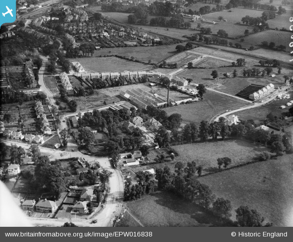
EPW016838 ENGLAND (1926). Rawlplug Works and environs, Edgware, 1926
© Copyright OpenStreetMap contributors and licensed by the OpenStreetMap Foundation. 2026. Cartography is licensed as CC BY-SA.
Nearby Images (13)
Details
| Title | [EPW016838] Rawlplug Works and environs, Edgware, 1926 |
| Reference | EPW016838 |
| Date | August-1926 |
| Link | |
| Place name | EDGWARE |
| Parish | |
| District | |
| Country | ENGLAND |
| Easting / Northing | 520598, 192195 |
| Longitude / Latitude | -0.25797322542576, 51.615176827601 |
| National Grid Reference | TQ206922 |
Pins

sashmantitch |
Sunday 20th of January 2019 06:52:04 PM | |

Captaintee |
Sunday 3rd of September 2017 03:32:50 PM | |

Captaintee |
Sunday 3rd of September 2017 03:29:11 PM |


![[EPW016838] Rawlplug Works and environs, Edgware, 1926](http://britainfromabove.org.uk/sites/all/libraries/aerofilms-images/public/100x100/EPW/016/EPW016838.jpg)
![[EPW034558] The Rawlplug Works and housing around Sefton Avenue, Edgware, from the north-east, 1930](http://britainfromabove.org.uk/sites/all/libraries/aerofilms-images/public/100x100/EPW/034/EPW034558.jpg)
![[EPW016836] Rawlplug Works, Edgware, 1926](http://britainfromabove.org.uk/sites/all/libraries/aerofilms-images/public/100x100/EPW/016/EPW016836.jpg)
![[EPW016833] Rawlplug Works, Edgware, 1926](http://britainfromabove.org.uk/sites/all/libraries/aerofilms-images/public/100x100/EPW/016/EPW016833.jpg)
![[EPW016832] Rawlplug Works, Edgware, 1926](http://britainfromabove.org.uk/sites/all/libraries/aerofilms-images/public/100x100/EPW/016/EPW016832.jpg)
![[EPW016841] Rawlplug Works and Dean's Drive houses under construction, Edgware, 1926](http://britainfromabove.org.uk/sites/all/libraries/aerofilms-images/public/100x100/EPW/016/EPW016841.jpg)
![[EPW016840] Rawlplug Works, Edgware, 1926](http://britainfromabove.org.uk/sites/all/libraries/aerofilms-images/public/100x100/EPW/016/EPW016840.jpg)
![[EPW016839] Rawlplug Works, Edgware, 1926](http://britainfromabove.org.uk/sites/all/libraries/aerofilms-images/public/100x100/EPW/016/EPW016839.jpg)
![[EPW016834] Rawlplug Works, Edgware, 1926](http://britainfromabove.org.uk/sites/all/libraries/aerofilms-images/public/100x100/EPW/016/EPW016834.jpg)
![[EPW016837] Rawlplug Works, Edgware, 1926](http://britainfromabove.org.uk/sites/all/libraries/aerofilms-images/public/100x100/EPW/016/EPW016837.jpg)
![[EPW016835] Rawlplug Works, Edgware, 1926](http://britainfromabove.org.uk/sites/all/libraries/aerofilms-images/public/100x100/EPW/016/EPW016835.jpg)
![[EPW034559] New housing at Orchard Crescent, Edgware, from the north-east, 1930](http://britainfromabove.org.uk/sites/all/libraries/aerofilms-images/public/100x100/EPW/034/EPW034559.jpg)
![[EPW035552] Housing surrounding Orchard Crescent, the Rawplug Co Ltd Works and environs, Mill Hill, 1931](http://britainfromabove.org.uk/sites/all/libraries/aerofilms-images/public/100x100/EPW/035/EPW035552.jpg)