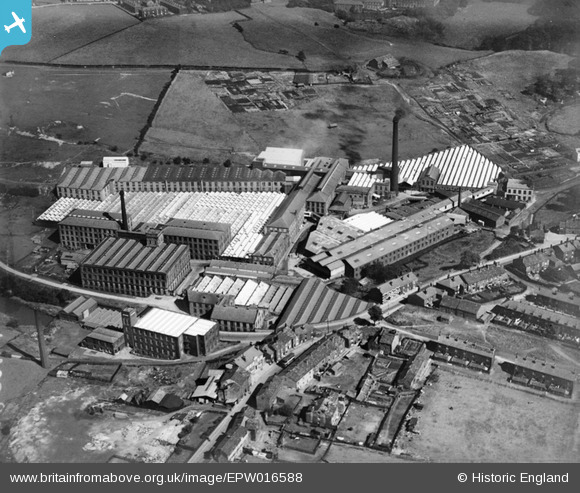
EPW016588 ENGLAND (1926). Cotton and Woollen Mills and Asbestos and India Rubber Works, Rochdale, 1926
© Copyright OpenStreetMap contributors and licensed by the OpenStreetMap Foundation. 2026. Cartography is licensed as CC BY-SA.
Nearby Images (14)
Details
| Title | [EPW016588] Cotton and Woollen Mills and Asbestos and India Rubber Works, Rochdale, 1926 |
| Reference | EPW016588 |
| Date | 27-August-1926 |
| Link | |
| Place name | ROCHDALE |
| Parish | |
| District | |
| Country | ENGLAND |
| Easting / Northing | 388336, 414508 |
| Longitude / Latitude | -2.176384880087, 53.626739786841 |
| National Grid Reference | SD883145 |
Pins

JohnF |
Tuesday 23rd of October 2012 09:37:02 PM |
User Comment Contributions
This must be the mill complex in Spodden valley.The river Spodden flows through the site on its way to the rivers Roche,Irwell and Mersey.If so,the asbestos and rubber works is the infamous Turner & Newall plant,source of recent controversy; Google Spodden Valley for details. On a lighter note,the river takes its name from a Saxon lord, Wolfric Spot, who would be amazed to know that a football stadium,Spotland,had been named after him. JohnF |

JohnF |
Wednesday 15th of August 2012 10:03:58 PM |


![[EPW016588] Cotton and Woollen Mills and Asbestos and India Rubber Works, Rochdale, 1926](http://britainfromabove.org.uk/sites/all/libraries/aerofilms-images/public/100x100/EPW/016/EPW016588.jpg)
![[EPW016592] Cotton and Woollen Mills and Asbestos and India Rubber Works, Rochdale, 1926](http://britainfromabove.org.uk/sites/all/libraries/aerofilms-images/public/100x100/EPW/016/EPW016592.jpg)
![[EPW016589] Cotton and Woollen Mills and Asbestos and India Rubber Works, Rochdale, 1926](http://britainfromabove.org.uk/sites/all/libraries/aerofilms-images/public/100x100/EPW/016/EPW016589.jpg)
![[EPW016591] Cotton and Woollen Mills and Asbestos and India Rubber Works, Rochdale, 1926](http://britainfromabove.org.uk/sites/all/libraries/aerofilms-images/public/100x100/EPW/016/EPW016591.jpg)
![[EPW045806] Turner Brothers Asbestos and India Rubber Works, Rochdale, 1934](http://britainfromabove.org.uk/sites/all/libraries/aerofilms-images/public/100x100/EPW/045/EPW045806.jpg)
![[EPW045812] Turner Brothers Asbestos and India Rubber Works, Rochdale, 1934](http://britainfromabove.org.uk/sites/all/libraries/aerofilms-images/public/100x100/EPW/045/EPW045812.jpg)
![[EPW016593] Cotton and Woollen Mills and Asbestos and India Rubber Works, Rochdale, 1926](http://britainfromabove.org.uk/sites/all/libraries/aerofilms-images/public/100x100/EPW/016/EPW016593.jpg)
![[EPW016590] Cotton and Woollen Mills and Asbestos and India Rubber Works, Rochdale, 1926](http://britainfromabove.org.uk/sites/all/libraries/aerofilms-images/public/100x100/EPW/016/EPW016590.jpg)
![[EPW045809] Turner Brothers Asbestos and India Rubber Works, Rochdale, 1934](http://britainfromabove.org.uk/sites/all/libraries/aerofilms-images/public/100x100/EPW/045/EPW045809.jpg)
![[EPW045807] Turner Brothers Asbestos and India Rubber Works, Rochdale, 1934](http://britainfromabove.org.uk/sites/all/libraries/aerofilms-images/public/100x100/EPW/045/EPW045807.jpg)
![[EPW045811] Turner Brothers Asbestos and India Rubber Works, Rochdale, 1934](http://britainfromabove.org.uk/sites/all/libraries/aerofilms-images/public/100x100/EPW/045/EPW045811.jpg)
![[EPW045808] Turner Brothers Asbestos and India Rubber Works, Rochdale, 1934](http://britainfromabove.org.uk/sites/all/libraries/aerofilms-images/public/100x100/EPW/045/EPW045808.jpg)
![[EPW045810] Turner Brothers Asbestos and India Rubber Works, Rochdale, 1934](http://britainfromabove.org.uk/sites/all/libraries/aerofilms-images/public/100x100/EPW/045/EPW045810.jpg)
![[EPW045805] Turner Brothers Asbestos and India Rubber Works, Rochdale, 1934](http://britainfromabove.org.uk/sites/all/libraries/aerofilms-images/public/100x100/EPW/045/EPW045805.jpg)