
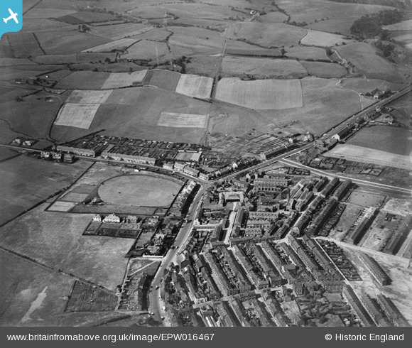
EPW016467 ENGLAND (1926). The junction of Hollin Lane and the Rochdale Road, Middleton, 1926
© Copyright OpenStreetMap contributors and licensed by the OpenStreetMap Foundation. 2026. Cartography is licensed as CC BY-SA.
Nearby Images (2)
EPW016467

EPW016461

Details
| Title | [EPW016467] The junction of Hollin Lane and the Rochdale Road, Middleton, 1926 |
| Reference | EPW016467 |
| Date | 6-August-1926 |
| Link | |
| Place name | MIDDLETON |
| Parish | |
| District | |
| Country | ENGLAND |
| Easting / Northing | 387171, 406909 |
| Longitude / Latitude | -2.1936894476799, 53.558403064493 |
| National Grid Reference | SD872069 |
Pins

Geoff Wellens |
Friday 19th of October 2012 08:35:13 PM | |
|
Geoff Wellens |
Friday 19th of October 2012 08:34:13 PM | |
|
Geoff Wellens |
Friday 19th of October 2012 08:33:02 PM | |
|
Geoff Wellens |
Friday 19th of October 2012 08:32:09 PM | |
|
Geoff Wellens |
Friday 19th of October 2012 08:31:05 PM | |
|
Geoff Wellens |
Friday 19th of October 2012 08:28:53 PM | |
|
Geoff Wellens |
Friday 19th of October 2012 08:21:13 PM | |
|
Geoff Wellens |
Friday 19th of October 2012 08:19:00 PM | |
|
Geoff Wellens |
Friday 19th of October 2012 08:17:47 PM | |
|
Geoff Wellens |
Friday 19th of October 2012 08:16:58 PM | |
|
Geoff Wellens |
Friday 19th of October 2012 08:14:17 PM | |
|
Geoff Wellens |
Friday 19th of October 2012 08:13:34 PM | |
|
Geoff Wellens |
Friday 19th of October 2012 08:11:56 PM | |
|
Geoff Wellens |
Friday 19th of October 2012 08:02:57 PM | |
|
Geoff Wellens |
Friday 19th of October 2012 08:01:09 PM | |
|
Moonraker2 |
Friday 17th of August 2012 12:13:48 AM | |
|
Al Roach |
Tuesday 17th of July 2012 08:55:43 PM | |
|
Al Roach |
Tuesday 17th of July 2012 08:53:45 PM | |
|
Al Roach |
Tuesday 17th of July 2012 08:53:06 PM | |
This was the second of two mills in Middleton owned by the Yorkshire Dyeing Company, the other being off Hanson St. |
Geoff Wellens |
Friday 19th of October 2012 08:37:22 PM |