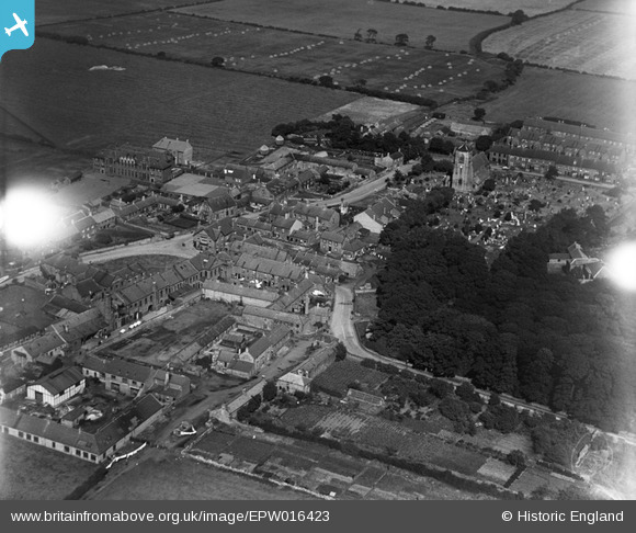
EPW016423 ENGLAND (1926). St Nicholas's Church and the village centre, Cramlington, 1926
© Copyright OpenStreetMap contributors and licensed by the OpenStreetMap Foundation. 2025. Cartography is licensed as CC BY-SA.
Details
| Title | [EPW016423] St Nicholas's Church and the village centre, Cramlington, 1926 |
| Reference | EPW016423 |
| Date | 29-July-1926 |
| Link | |
| Place name | CRAMLINGTON |
| Parish | CRAMLINGTON |
| District | |
| Country | ENGLAND |
| Easting / Northing | 426591, 576941 |
| Longitude / Latitude | -1.5833767957617, 55.086133871427 |
| National Grid Reference | NZ266769 |
Pins

Adam |
Thursday 25th of February 2021 04:46:29 PM | |

Adam |
Thursday 25th of February 2021 04:44:16 PM | |

Adam |
Thursday 25th of February 2021 04:43:43 PM | |

Adam |
Thursday 25th of February 2021 04:42:49 PM | |

Adam |
Thursday 25th of February 2021 04:42:24 PM | |

Adam |
Thursday 25th of February 2021 04:41:50 PM | |

Adam |
Thursday 25th of February 2021 04:41:26 PM | |

Adam |
Thursday 25th of February 2021 04:40:41 PM | |

Adam |
Thursday 25th of February 2021 04:40:18 PM |
User Comment Contributions
yem |

ED HINDHAUGH |
Friday 22nd of November 2013 08:42:11 PM |


![[EPW016423] St Nicholas's Church and the village centre, Cramlington, 1926](http://britainfromabove.org.uk/sites/all/libraries/aerofilms-images/public/100x100/EPW/016/EPW016423.jpg)
![[EPW016424] St Nicholas's Church and the village, Cramlington, 1926](http://britainfromabove.org.uk/sites/all/libraries/aerofilms-images/public/100x100/EPW/016/EPW016424.jpg)
![[EPW016422] St Nicholas's Church and the village centre, Cramlington, 1926](http://britainfromabove.org.uk/sites/all/libraries/aerofilms-images/public/100x100/EPW/016/EPW016422.jpg)