
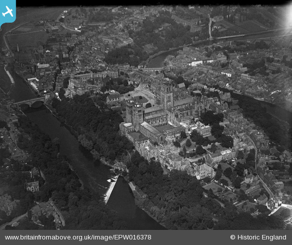
EPW016378 ENGLAND (1926). The Cathedral Church of Christ and St Mary the Virgin and the castle, Durham, 1926
© Copyright OpenStreetMap contributors and licensed by the OpenStreetMap Foundation. 2026. Cartography is licensed as CC BY-SA.
Nearby Images (25)
EPW016378

EPW016377

EAW007837

EAW017465

EAW014484

EAW007839

EAW007838

EAW014485

EPW016376

EAW014482

EAW005521

EAW005524

EAW005520

EAW017463

EAW014483

EAW005523

EPW026650

EPW026591

EAW014481

EAW005522

EPW026649

EPW026648

EAW014480

EAW007832

EPW026647

Details
| Title | [EPW016378] The Cathedral Church of Christ and St Mary the Virgin and the castle, Durham, 1926 |
| Reference | EPW016378 |
| Date | 29-July-1926 |
| Link | |
| Place name | DURHAM |
| Parish | |
| District | |
| Country | ENGLAND |
| Easting / Northing | 427312, 542145 |
| Longitude / Latitude | -1.5753873274683, 54.773380467102 |
| National Grid Reference | NZ273421 |
Pins

Peter J |
Saturday 19th of February 2022 12:48:25 PM | |

Class31 |
Monday 22nd of October 2012 11:47:32 PM | |
|
Class31 |
Monday 22nd of October 2012 11:47:04 PM | |
|
Class31 |
Monday 22nd of October 2012 11:46:39 PM | |
|
Class31 |
Monday 22nd of October 2012 11:44:46 PM | |
|
anwyn |
Tuesday 24th of July 2012 08:04:00 PM | |
|
anwyn |
Tuesday 24th of July 2012 08:02:41 PM | |
|
anwyn |
Tuesday 24th of July 2012 08:01:33 PM | |
|
anwyn |
Tuesday 24th of July 2012 07:59:27 PM |
User Comment Contributions

An original period photograph entitled "Castle from River" showing Framwellgate Bridge taken June or July 1939 |
Class31 |
Tuesday 6th of May 2014 02:38:33 PM |