
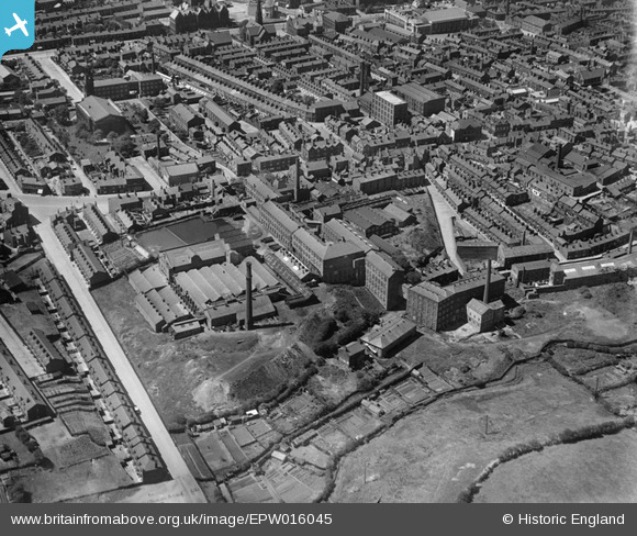
EPW016045 ENGLAND (1926). The Christy and Co. Hillgate Hat Manufactory and environs, Stockport, 1926
© Copyright OpenStreetMap contributors and licensed by the OpenStreetMap Foundation. 2025. Cartography is licensed as CC BY-SA.
Nearby Images (5)
EPW016045

EPW016040

EPW016044

EPW016041

EPW016042

Details
| Title | [EPW016045] The Christy and Co. Hillgate Hat Manufactory and environs, Stockport, 1926 |
| Reference | EPW016045 |
| Date | 2-July-1926 |
| Link | |
| Place name | STOCKPORT |
| Parish | |
| District | |
| Country | ENGLAND |
| Easting / Northing | 390007, 389767 |
| Longitude / Latitude | -2.1503266133885, 53.404367432787 |
| National Grid Reference | SJ900898 |
Pins

woodsmoor history project |
Thursday 26th of January 2023 06:10:27 PM | |

Class31 |
Monday 17th of June 2013 08:38:23 AM | |
|
Class31 |
Monday 17th of June 2013 08:36:54 AM | |
|
Class31 |
Monday 17th of June 2013 08:32:37 AM | |
|
Class31 |
Monday 17th of June 2013 08:30:57 AM | |
|
Class31 |
Monday 17th of June 2013 08:30:08 AM | |
|
Class31 |
Monday 17th of June 2013 08:28:53 AM | |
|
Class31 |
Monday 17th of June 2013 08:28:04 AM | |
|
Class31 |
Monday 17th of June 2013 08:27:15 AM | |
|
Class31 |
Monday 17th of June 2013 08:25:53 AM | |
|
totoro |
Tuesday 18th of December 2012 10:33:18 PM | |
|
totoro |
Tuesday 18th of December 2012 10:31:55 PM | |
|
totoro |
Tuesday 18th of December 2012 10:30:46 PM | |
|
totoro |
Tuesday 18th of December 2012 10:28:25 PM | |
|
totoro |
Tuesday 18th of December 2012 10:27:58 PM |
User Comment Contributions
View looking west. |
Class31 |
Monday 17th of June 2013 08:39:41 AM |